IMAGES TAKEN NEAR TO
Saxmundham Road, WOODBRIDGE, IP13 9DB
Introduction
This page details the photographs taken nearby to Saxmundham Road, IP13 9DB by members of the Geograph project.
The Geograph project started in 2005 with the aim of publishing, organising and preserving representative images for every square kilometre of Great Britain, Ireland and the Isle of Man.

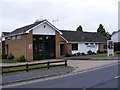
There are currently over 7.5m images from over14,400 individuals and you can help contribute to the project by visiting https://www.geograph.org.uk
Image Map
Images are licensed for reuse under creativecommons.org/licenses/by-sa/2.0
Notes
- Clicking on the map will re-center to the selected point.
- The higher the marker number, the further away the image location is from the centre of the postcode.
Image Listing (579 Images Found)
Images are licensed for reuse under creativecommons.org/licenses/by-sa/2.0
Image
Details
Distance
1
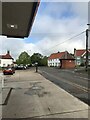
View from Filling Station in Framlingham
Image: © Dave Thompson
Taken: 16 May 2021
0.02 miles
2
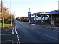
B1119 Saxmundham Road, Framlingham
At the junction with the B1120 Badingham Road
Image: © Geographer
Taken: 7 Dec 2008
0.02 miles
3
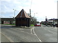
Old Water Pump Shelter
Old water pump shelter given by Anne Jeaffreson in memory of her father and mother on the 29 September 1896.
Image: © Keith Evans
Taken: 2 Mar 2014
0.02 miles
4
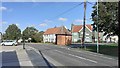
Framlingham-The Site of Jefferson's Well
On Saxmundham Road.
Image: © Ian Rob
Taken: 18 Sep 2020
0.02 miles
5
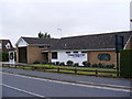
Framlingham Fire Station
Off the B1119 Saxmundham Road
Image: © Geographer
Taken: 13 Jul 2010
0.02 miles
6
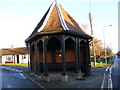
Jeaffreson's Well
At the junction of The B1120 Badingham Road and the B1119 Saxmundham Road & Castle Street.
Jeaffreson's Well was sunk in 1896 in memory of town doctor William Jeaffreson FRCS and his wife Caroline. It was covered with a conical roofed, open-sided structure. Isaac Larter was the first man to make use of this supply communally when he put a tank in the roof to supply the bungalows he had built in Saxmundham Road in the 1930s.
Image: © Geographer
Taken: 7 Dec 2008
0.03 miles
7
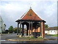
Jeaffreson's Well, Framlingham
The well was sunk in 1896, named in memory of Framlingham's town doctor, Dr Jeaffreson. The well is now disused but its shelter remains in place.
Image: © Malc McDonald
Taken: 25 Sep 2010
0.03 miles
8
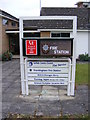
Framlingham Fire Station sign
Off the B1119 Saxmundham Road
Image: © Geographer
Taken: 13 Jul 2010
0.03 miles
9
Plaque on Jeaffreson's Well
At the junction of The B1120 Badingham Road and the B1119 Saxmundham Road & Castle Street.
Jeaffreson's Well was sunk in 1896 in memory of town doctor William Jeaffreson FRCS and his wife Caroline. It was covered with a conical roofed, open-sided structure. Isaac Larter was the first man to make use of this supply communally when he put a tank in the roof to supply the bungalows he had built in Saxmundham Road in the 1930s.
Image: © Geographer
Taken: 7 Dec 2008
0.03 miles
10
Framlingham Fire Station
Off the B1119 Saxmundham Road
Image: © Geographer
Taken: 13 Jul 2010
0.03 miles