IMAGES TAKEN NEAR TO
High Road, WOODBRIDGE, IP13 8NB
Introduction
This page details the photographs taken nearby to High Road, IP13 8NB by members of the Geograph project.
The Geograph project started in 2005 with the aim of publishing, organising and preserving representative images for every square kilometre of Great Britain, Ireland and the Isle of Man.

There are currently over 7.5m images from over14,400 individuals and you can help contribute to the project by visiting https://www.geograph.org.uk
Image Map
Images are licensed for reuse under creativecommons.org/licenses/by-sa/2.0
Notes
- Clicking on the map will re-center to the selected point.
- The higher the marker number, the further away the image location is from the centre of the postcode.
Image Listing (9 Images Found)
Images are licensed for reuse under creativecommons.org/licenses/by-sa/2.0
Image
Details
Distance
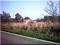

3
Rich green of Winter wheat beside the A1120 at Badingham
Image: © Adrian S Pye
Taken: 22 Feb 2011
0.06 miles
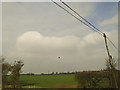
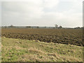
4
Field of Winter wheat beside the A1120
Image: © Adrian S Pye
Taken: 22 Feb 2011
0.06 miles
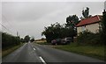
6
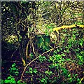
ROC Post Badingham
Badingham Post was commissioned in March 1949 and was closed due to ROC restructuring in October 1968. The site during the posts operational life was prone to flooding due to its location. Repairs were made to external walls to help prevent this; but all attempts ultimately failed. During the late 1990's talks were held by Badingham Parish Council to have the site protected but have failed to have the site listed. The Post is located on the High Street (South) near to Trust Farm.
Image: © Cud05
Taken: 3 May 2015
0.09 miles
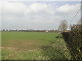
8
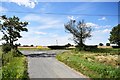
Badingham: Looking towards the A1120 from Hollow Lane
Image: © Michael Garlick
Taken: 29 Jul 2020
0.21 miles
9
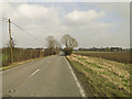
A short stretch of the Roman road east of Badingham
Image: © Adrian S Pye
Taken: 22 Feb 2011
0.22 miles