IMAGES TAKEN NEAR TO
The Street, WOODBRIDGE, IP13 8BP
Introduction
This page details the photographs taken nearby to The Street, IP13 8BP by members of the Geograph project.
The Geograph project started in 2005 with the aim of publishing, organising and preserving representative images for every square kilometre of Great Britain, Ireland and the Isle of Man.

There are currently over 7.5m images from over14,400 individuals and you can help contribute to the project by visiting https://www.geograph.org.uk
Image Map
Images are licensed for reuse under creativecommons.org/licenses/by-sa/2.0
Notes
- Clicking on the map will re-center to the selected point.
- The higher the marker number, the further away the image location is from the centre of the postcode.
Image Listing (5 Images Found)
Images are licensed for reuse under creativecommons.org/licenses/by-sa/2.0
Image
Details
Distance
1
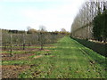
Apple orchard
Apple orchard at Valley farm near to Brundish Suffolk.
Image: © Keith Evans
Taken: 25 Nov 2007
0.17 miles
2
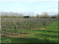
Apple Orchard
Apple orchard near to Brundish Street, Suffolk.
Image: © Keith Evans
Taken: 13 Mar 2014
0.18 miles
3
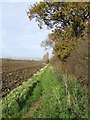
Where has the orchard gone ?
The ploughed field is still marked on the O.S. maps as being orchard near to Brundish Suffolk.
Image: © Keith Evans
Taken: 25 Nov 2007
0.19 miles
4
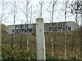
Footpath signs
Footpath signs near to Brundish Suffolk.
Image: © Keith Evans
Taken: 25 Nov 2007
0.19 miles
5
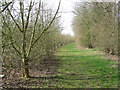
Orchard
View of an orchard next to the footpath near to Brundish Street, Suffolk.
Image: © Keith Evans
Taken: 13 Mar 2014
0.25 miles