IMAGES TAKEN NEAR TO
Bedfield Road, WOODBRIDGE, IP13 7EJ
Introduction
This page details the photographs taken nearby to Bedfield Road, IP13 7EJ by members of the Geograph project.
The Geograph project started in 2005 with the aim of publishing, organising and preserving representative images for every square kilometre of Great Britain, Ireland and the Isle of Man.

There are currently over 7.5m images from over14,400 individuals and you can help contribute to the project by visiting https://www.geograph.org.uk
Image Map
Images are licensed for reuse under creativecommons.org/licenses/by-sa/2.0
Notes
- Clicking on the map will re-center to the selected point.
- The higher the marker number, the further away the image location is from the centre of the postcode.
Image Listing (23 Images Found)
Images are licensed for reuse under creativecommons.org/licenses/by-sa/2.0
Image
Details
Distance

3
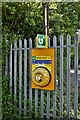
Monk Soham: Defibrillator situated outside Jewsons
Image: © Michael Garlick
Taken: 8 May 2020
0.03 miles

9

Bedfield, private cottage: VE Day 75th anniversary piece 'Star Wars'
Image: © Michael Garlick
Taken: 8 May 2020
0.18 miles
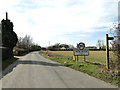
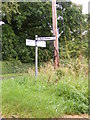
10
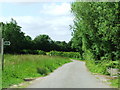
Footpath and Country Road
Footpath sign and country road near to Monk Soham, Suffolk.
Image: © Keith Evans
Taken: 20 Jun 2010
0.19 miles