IMAGES TAKEN NEAR TO
Bedfield, WOODBRIDGE, IP13 7EG
Introduction
This page details the photographs taken nearby to IP13 7EG by members of the Geograph project.
The Geograph project started in 2005 with the aim of publishing, organising and preserving representative images for every square kilometre of Great Britain, Ireland and the Isle of Man.

There are currently over 7.5m images from over14,400 individuals and you can help contribute to the project by visiting https://www.geograph.org.uk
Image Map
Images are licensed for reuse under creativecommons.org/licenses/by-sa/2.0
Notes
- Clicking on the map will re-center to the selected point.
- The higher the marker number, the further away the image location is from the centre of the postcode.
Image Listing (19 Images Found)
Images are licensed for reuse under creativecommons.org/licenses/by-sa/2.0
Image
Details
Distance
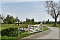
1
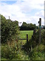
Footpath to Bullswood Lane Byway
Near to Worlingworth Cricket Club
Image: © Geographer
Taken: 25 Aug 2011
0.18 miles
2
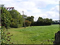
Footpath to Bullswood Lane Byway
Near to Worlingworth Cricket Club
Image: © Geographer
Taken: 25 Aug 2011
0.19 miles
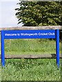
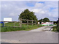
4
The entrance to Worlingworth Cricket Club
Image: © Geographer
Taken: 25 Aug 2011
0.20 miles
5
The entrance to Worlingworth Cricket Club
Image: © Geographer
Taken: 25 Aug 2011
0.20 miles
7
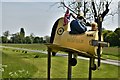
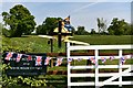
Bedfield, White House Farm: VE Day 75th anniversary piece
Image: © Michael Garlick
Taken: 8 May 2020
0.22 miles
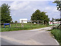
8
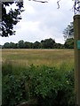
Footpath to Bedfield Little Green
Off Dog Lane
Image: © Geographer
Taken: 7 Jun 2011
0.22 miles
10
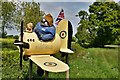
Bedfield, White House Farm: VE Day 75th anniversary piece
Image: © Michael Garlick
Taken: 8 May 2020
0.23 miles