IMAGES TAKEN NEAR TO
Brandeston Road, WOODBRIDGE, IP13 7DS
Introduction
This page details the photographs taken nearby to Brandeston Road, IP13 7DS by members of the Geograph project.
The Geograph project started in 2005 with the aim of publishing, organising and preserving representative images for every square kilometre of Great Britain, Ireland and the Isle of Man.

There are currently over 7.5m images from over14,400 individuals and you can help contribute to the project by visiting https://www.geograph.org.uk
Image Map
Images are licensed for reuse under creativecommons.org/licenses/by-sa/2.0
Notes
- Clicking on the map will re-center to the selected point.
- The higher the marker number, the further away the image location is from the centre of the postcode.
Image Listing (28 Images Found)
Images are licensed for reuse under creativecommons.org/licenses/by-sa/2.0
Image
Details
Distance
1
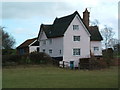
Old Cottage
Old cottage near to Brandeston Suffolk.
Image: © Keith Evans
Taken: 13 Feb 2007
0.01 miles
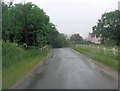
3
Old Maid's Lane, Brandeston
At Brandeston Bridge near The Potash
Image: © Geographer
Taken: 21 Nov 2013
0.02 miles
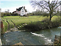
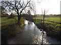
5
Brandeston Road crosses Brandeston Bridge
Underneath the road flows the River Deben.
Image: © Stuart Logan
Taken: 27 Jun 2013
0.03 miles
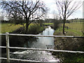
6
River Deben at Brandeston Bridge
Off Old Maid's Lane
Image: © Geographer
Taken: 21 Nov 2013
0.03 miles
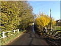
9
Looking towards Brandeston Bridge
From Friday Street at the junction with the road to Kittle's Corner.
Image: © Geographer
Taken: 21 Nov 2013
0.04 miles
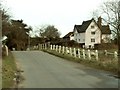
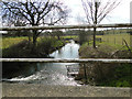
10
Brandeston Bridge on Old Maid's Lane
Over the River Deben
Image: © Geographer
Taken: 21 Nov 2013
0.04 miles