IMAGES TAKEN NEAR TO
Burgh, WOODBRIDGE, IP13 6SU
Introduction
This page details the photographs taken nearby to IP13 6SU by members of the Geograph project.
The Geograph project started in 2005 with the aim of publishing, organising and preserving representative images for every square kilometre of Great Britain, Ireland and the Isle of Man.

There are currently over 7.5m images from over14,400 individuals and you can help contribute to the project by visiting https://www.geograph.org.uk
Image Map
Images are licensed for reuse under creativecommons.org/licenses/by-sa/2.0
Notes
- Clicking on the map will re-center to the selected point.
- The higher the marker number, the further away the image location is from the centre of the postcode.
Image Listing (44 Images Found)
Images are licensed for reuse under creativecommons.org/licenses/by-sa/2.0
Image
Details
Distance
1
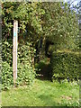
Footpath to Hasketon Road
Off Seven Gardens Road
Image: © Geographer
Taken: 28 Jul 2011
0.04 miles
2
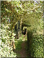
Footpath to Hasketon Road
Off Seven Gardens Road
Image: © Geographer
Taken: 28 Jul 2011
0.05 miles
3
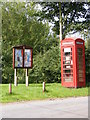
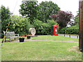
Burgh Village Notice Board & Telephone Box
Off Seven Gardens Road
Image: © Geographer
Taken: 28 Jul 2011
0.09 miles
4
Burgh Village Sign
Off Seven Gardens Road at the junction with White Foot Lane
Image: © Geographer
Taken: 28 Jul 2011
0.09 miles
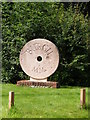
5
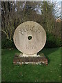
Millennial millstone at Burgh
On a small green in the middle of the hamlet.
Image: © Oliver Dixon
Taken: 25 Apr 2017
0.10 miles
6
Burgh village sign in the form of a mill stone
Burgh village sign is in the form of a mill stone. https://www.geograph.org.uk/photo/6759650 It represents Burgh Mill which is a seven storey tower mill with an ogee cap with a gallery. Built in 1842 it replaced an earlier mill. In 1919, an 8 horsepower engine was installed. The mill worked by wind until 1922. The machinery was dismantled in 1925. From July 1940 the mill became home to an Observer Corps post. https://www.geograph.org.uk/photo/6759670
Image: © Adrian S Pye
Taken: 23 Jun 2015
0.10 miles
7
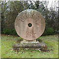
Burgh village "sign"
Burgh village sign is in the form of a mill stone. It represents Burgh Mill which is a seven storey tower mill with an ogee cap with a gallery. Built in 1842 it replaced an earlier mill. In 1919, an 8 horsepower engine was installed. The mill worked by wind until 1922. The machinery was dismantled in 1925. From July 1940 the mill became home to an Observer Corps post. https://www.geograph.org.uk/photo/4537400
Image: © Adrian S Pye
Taken: 15 Feb 2021
0.10 miles
8
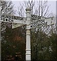
Direction Sign ? Signpost
Located on the northwest side of the crossroads of Mill Hill, White Foot Lane, Seven Gardens Road and Hasketon Road in Burgh parish. 4 arms and bishop finial. See also https://www.geograph.org.uk/photo/3837549.
Milestone Society National ID: SU_TM2351
Image: © A Lloyd
Taken: 24 Feb 2020
0.10 miles
9
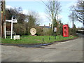
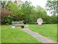
Village Centre
The centre of Burgh, Suffolk with telephone box, seat and village name sign on a mill stone.
Image: © Keith Evans
Taken: 2 Feb 2014
0.11 miles
10
Village Sign
Village name sign at Burgh, Suffolk.
Image: © Keith Evans
Taken: 2 Feb 2014
0.11 miles