IMAGES TAKEN NEAR TO
Bonds Corner, WOODBRIDGE, IP13 6RU
Introduction
This page details the photographs taken nearby to Bonds Corner, IP13 6RU by members of the Geograph project.
The Geograph project started in 2005 with the aim of publishing, organising and preserving representative images for every square kilometre of Great Britain, Ireland and the Isle of Man.

There are currently over 7.5m images from over14,400 individuals and you can help contribute to the project by visiting https://www.geograph.org.uk
Image Map
Images are licensed for reuse under creativecommons.org/licenses/by-sa/2.0
Notes
- Clicking on the map will re-center to the selected point.
- The higher the marker number, the further away the image location is from the centre of the postcode.
Image Listing (16 Images Found)
Images are licensed for reuse under creativecommons.org/licenses/by-sa/2.0
Image
Details
Distance
1
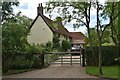
Poplar Farmhouse, Grundisburgh
The house dates back to the late 16th Century and is a Grade II Listed Building. It used to be the farmhouse of the adjacent Poplar Farm.
Image: © Simon Mortimer
Taken: 17 Jul 2020
0.00 miles
5
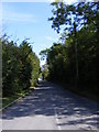
Stoney Road
Looking towards Grundisburgh near the Crossroads
Image: © Geographer
Taken: 19 Aug 2011
0.11 miles
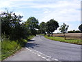
6
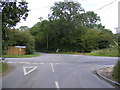
Otley Road at Bond's Corner crossroads
The junction of Otley, Clopton & Stoney Roads
Image: © Geographer
Taken: 25 Aug 2011
0.12 miles
7
Road to the B1078
At the Stoney Road Crossroads at Bond Corner
Image: © Geographer
Taken: 19 Aug 2011
0.12 miles
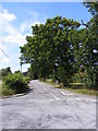
8
Stoney Road Crossroads
At the junction with Clopton Road
Image: © Geographer
Taken: 19 Aug 2011
0.12 miles
9
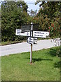
Roadsign at the Stoney/Clopton Road Crossroads
Image: © Geographer
Taken: 19 Aug 2011
0.13 miles
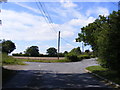
10
Clopton Road
Looking towards Grundisburgh Road at the junction with Stoney Road & Market Hill
Image: © Geographer
Taken: 19 Aug 2011
0.13 miles