IMAGES TAKEN NEAR TO
High Street, WOODBRIDGE, IP13 6EQ
Introduction
This page details the photographs taken nearby to High Street, IP13 6EQ by members of the Geograph project.
The Geograph project started in 2005 with the aim of publishing, organising and preserving representative images for every square kilometre of Great Britain, Ireland and the Isle of Man.

There are currently over 7.5m images from over14,400 individuals and you can help contribute to the project by visiting https://www.geograph.org.uk
Image Map
Images are licensed for reuse under creativecommons.org/licenses/by-sa/2.0
Notes
- Clicking on the map will re-center to the selected point.
- The higher the marker number, the further away the image location is from the centre of the postcode.
Image Listing (51 Images Found)
Images are licensed for reuse under creativecommons.org/licenses/by-sa/2.0
Image
Details
Distance
1
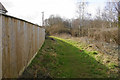
Path round the edge of Ufford
Linking Yarmouth Road with Byng Hall Road.
Image: © Bill Boaden
Taken: 23 Mar 2018
0.01 miles
2
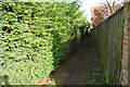
Footpath leaving High Street
A footpath traversing the northern edge of Ufford.
Image: © Bill Boaden
Taken: 23 Mar 2018
0.03 miles
3
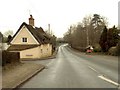
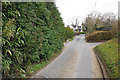
Yarmouth Road in Ufford
This is the B.1438 that used to be the old A.12
Image: © Robert Edwards
Taken: 5 Feb 2007
0.04 miles
4
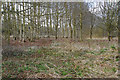
Woodland near Ufford
The trees to the left are planted in straight lines though it is not apparent from here.
Image: © Bill Boaden
Taken: 23 Mar 2018
0.04 miles
5
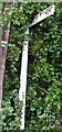
Old Direction Sign - Signpost by the B1438, High Street, Ufford
No finial - 1 arm; by the B1438, in parish of Ufford (Suffolk Coastal District), Ufford, junction of High Street with Yarmouth Road and Crownfields, almost hidden in a hedge, next to telegraph pole.
Surveyed
Milestone Society National ID: SU_TM2952
Image: © Milestone Society
Taken: Unknown
0.07 miles
7
Old Cast Iron Milepost
Old cast iron milepost Ufford, Suffolk. For close up view see http://www.geograph.org.uk/photo/1159458 and for more info on the post see http://milestones.megalithia.com/sites/tm294534.htm do look at their home page.
Image: © Keith Evans
Taken: 12 Feb 2009
0.10 miles
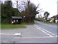
8
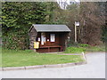
Bus Shelter on Byng Hall Road
At the junction of the B1438 High Street
Image: © Geographer
Taken: 16 Apr 2010
0.10 miles
9
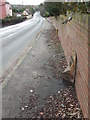
B1438 High Street
Looking towards Ufford at the junction Byng Hall Road
Image: © Geographer
Taken: 16 Apr 2010
0.10 miles
10
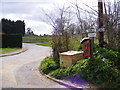
Lodge Road, Ufford
At the junction with Byng Hall Road
Image: © Geographer
Taken: 16 Apr 2010
0.11 miles