IMAGES TAKEN NEAR TO
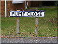
Pump Close, WOODBRIDGE, IP13 6DD
Introduction
This page details the photographs taken nearby to Pump Close, IP13 6DD by members of the Geograph project.
The Geograph project started in 2005 with the aim of publishing, organising and preserving representative images for every square kilometre of Great Britain, Ireland and the Isle of Man.

There are currently over 7.5m images from over14,400 individuals and you can help contribute to the project by visiting https://www.geograph.org.uk
Image Map
Images are licensed for reuse under creativecommons.org/licenses/by-sa/2.0
Notes
- Clicking on the map will re-center to the selected point.
- The higher the marker number, the further away the image location is from the centre of the postcode.
Image Listing (34 Images Found)
Images are licensed for reuse under creativecommons.org/licenses/by-sa/2.0
Image
Details
Distance
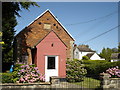
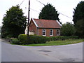
4
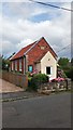
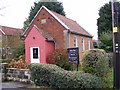
Congregational Chapel, Bredfield
Built in 1902.
Image: © Stuart Shepherd
Taken: 1 Aug 2019
0.04 miles
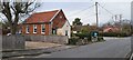
7
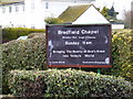
Bredfield Chapel Notice Board
Off Woodbridge Road
Image: © Geographer
Taken: 19 Jan 2009
0.05 miles
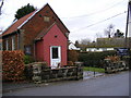
10
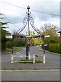
Village pump and signpost
A remarkable structure incorporating the village pump and signposts at the south end of Bredfield. National Cycle Network route 1 comes from the left and goes straight ahead.
Image: © Oliver Dixon
Taken: 25 Apr 2017
0.05 miles