IMAGES TAKEN NEAR TO
The Street, WOODBRIDGE, IP13 6AX

Introduction

This page details the photographs taken nearby to The Street, IP13 6AX by members of the Geograph project.

The Geograph project started in 2005 with the aim of publishing, organising and preserving representative images for every square kilometre of Great Britain, Ireland and the Isle of Man.

There are currently over 7.5m images from over14,400 individuals and you can help contribute to the project by visiting https://www.geograph.org.uk

Image Map


Images are licensed for reuse under creativecommons.org/licenses/by-sa/2.0
Notes
  • Clicking on the map will re-center to the selected point.
  • The higher the marker number, the further away the image location is from the centre of the postcode.

Image Listing (104 Images Found)

Images are licensed for reuse under creativecommons.org/licenses/by-sa/2.0
  • ...
Image
Details
Distance
1
Footpath to Caters Road & Scott's Lane at St.Andrew's Church
Off The Street
Image: © Geographer Taken: 18 Mar 2011
0.02 miles
2
Footpath to Caters Road & Scott's Lane & entrance to St.Andrew's Church
Off The Street
Image: © Geographer Taken: 18 Mar 2011
0.02 miles
3
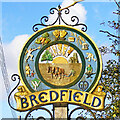
Bredfield village sign
In the centre the sun shines down on the church of St Andrew and the tree which represents the Jubilee meadow and orchard. The ploughman and horses show the village is primarily agricultural. Around the outer circle, travelling clockwise is the symbol of the Women’s Institute, a mother and child presumably representing family life as there is no school. A tennis player representing the two tennis courts. Pears, carrots and apples are grown in the village. The theatrical masks represent the Bedfield Amateur Dramatic Society. The loaf of bread for the shop, the ears of barley and mug show there was a pub, the Castle Inn. The man bowling represents the bowling green. The blacksmith who worked at his forge made all the gates for the Queen's estate at Sandringham. Finally the emblem of The Mother’s Union. The latest incarnation shows the detail blacked out, either the village has gone into serious decline or someone just can’t be bothered which is a shame. https://www.geograph.org.uk/photo/6746087 https://www.geograph.org.uk/photo/4291323
Image: © Adrian S Pye Taken: 9 Mar 2007
0.03 miles
4
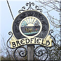
Bredfield village sign
In the centre the sun shines down on the church of St Andrew and the tree which represents the Jubilee meadow and orchard. The ploughman and horses show the village is primarily agricultural. Around the outer circle, travelling clockwise is the symbol of the Women’s Institute, a mother and child presumably representing family life as there is no school. A tennis player representing the two tennis courts. Pears, carrots and apples are grown in the village. The theatrical masks represent the Bedfield Amateur Dramatic Society. The loaf of bread for the shop, the ears of barley and mug show there was a pub, the Castle Inn. The man bowling represents the bowling green. The blacksmith who worked at his forge made all the gates for the Queen's estate at Sandringham. Finally the emblem of The Mother’s Union. The latest incarnation shows the detail blacked out, either the village has gone into serious decline or someone can’t be bothered which is a shame. https://www.geograph.org.uk/photo/4291323 https://www.geograph.org.uk/photo/6746079
Image: © Adrian S Pye Taken: 4 Feb 2021
0.03 miles
5
Bredfield, St Andrew: prayer desk
Image: © Basher Eyre Taken: 9 Aug 2010
0.03 miles
6
Bredfield, St Andrew: hatchment
Image: © Basher Eyre Taken: 9 Aug 2010
0.03 miles
7
Terraced houses opposite church, Bredfield
Image: © John Goldsmith Taken: 4 Feb 2007
0.03 miles
8
Bredfield, St Andrew: doorway
Image: © Basher Eyre Taken: 9 Aug 2010
0.03 miles
9
Bredfield, St Andrew: porch memorial
Image: © Basher Eyre Taken: 9 Aug 2010
0.03 miles
10
Bredfield, St Andrew: devotional texts (1)
Image: © Basher Eyre Taken: 9 Aug 2010
0.03 miles
  • ...