IMAGES TAKEN NEAR TO
Dallinghoo, WOODBRIDGE, IP13 0LG
Introduction
This page details the photographs taken nearby to IP13 0LG by members of the Geograph project.
The Geograph project started in 2005 with the aim of publishing, organising and preserving representative images for every square kilometre of Great Britain, Ireland and the Isle of Man.

There are currently over 7.5m images from over14,400 individuals and you can help contribute to the project by visiting https://www.geograph.org.uk
Image Map
Images are licensed for reuse under creativecommons.org/licenses/by-sa/2.0
Notes
- Clicking on the map will re-center to the selected point.
- The higher the marker number, the further away the image location is from the centre of the postcode.
Image Listing (26 Images Found)
Images are licensed for reuse under creativecommons.org/licenses/by-sa/2.0
Image
Details
Distance
1
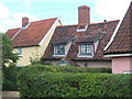
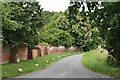
Glimpse of three cottages near Dallinghoo Hall
Image: © Andrew Hill
Taken: 25 Jun 2008
0.02 miles
2
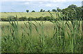
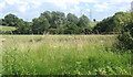
Fields near Dallinghoo, looking east
A few reeds in the foreground.
Image: © Andrew Hill
Taken: 25 Jun 2008
0.04 miles
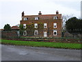
6
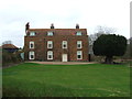
Dallinghoo Hall
Dallinghoo Hall near to Dallinghoo, Suffolk.
Image: © Keith Evans
Taken: 23 Feb 2014
0.18 miles
8
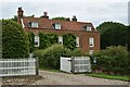
Dallinghoo Hall
Dallinghoo Hall dates back to the mid 18th Century and is a Grade II Listed Building.
Image: © Simon Mortimer
Taken: 18 Jul 2020
0.19 miles