IMAGES TAKEN NEAR TO
Dallinghoo, WOODBRIDGE, IP13 0JW
Introduction
This page details the photographs taken nearby to IP13 0JW by members of the Geograph project.
The Geograph project started in 2005 with the aim of publishing, organising and preserving representative images for every square kilometre of Great Britain, Ireland and the Isle of Man.

There are currently over 7.5m images from over14,400 individuals and you can help contribute to the project by visiting https://www.geograph.org.uk
Image Map
Images are licensed for reuse under creativecommons.org/licenses/by-sa/2.0
Notes
- Clicking on the map will re-center to the selected point.
- The higher the marker number, the further away the image location is from the centre of the postcode.
Image Listing (18 Images Found)
Images are licensed for reuse under creativecommons.org/licenses/by-sa/2.0
Image
Details
Distance
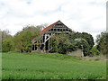
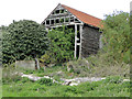
2
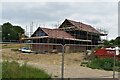
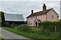
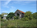
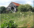
New house under construction at Valley Farm
The house sits on the site of a derelict barn at Valley farm, see Image for an image of its former condition.
Image: © Simon Mortimer
Taken: 18 Jul 2020
0.01 miles
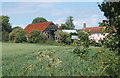
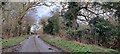
7
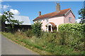
Valley Farm
By a lane junction between Dallinghoo and Wickham Market.
Image: © Andrew Hill
Taken: 25 Jun 2008
0.02 miles
9
Dallinghoo Docks, lane running along the Byng Brook valley
Image: © Christopher Hilton
Taken: 16 Mar 2023
0.13 miles
10
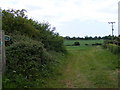
Footpath to Dallinghoo Road
Near White House Farm Cottages
Image: © Geographer
Taken: 19 May 2011
0.14 miles