IMAGES TAKEN NEAR TO
Pettistree, WOODBRIDGE, IP13 0JQ
Introduction
This page details the photographs taken nearby to IP13 0JQ by members of the Geograph project.
The Geograph project started in 2005 with the aim of publishing, organising and preserving representative images for every square kilometre of Great Britain, Ireland and the Isle of Man.

There are currently over 7.5m images from over14,400 individuals and you can help contribute to the project by visiting https://www.geograph.org.uk
Image Map
Images are licensed for reuse under creativecommons.org/licenses/by-sa/2.0
Notes
- Clicking on the map will re-center to the selected point.
- The higher the marker number, the further away the image location is from the centre of the postcode.
Image Listing (9 Images Found)
Images are licensed for reuse under creativecommons.org/licenses/by-sa/2.0
Image
Details
Distance
1
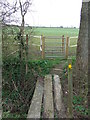
Footbridge
Footbridge near to Bredfield, Suffolk.
Image: © Keith Evans
Taken: 23 Feb 2014
0.06 miles
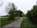
2
Footpath & Entrance to Stone Hall
Off Byng Hall Road
Image: © Geographer
Taken: 5 May 2011
0.14 miles
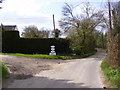
3
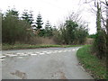
Road Junction
Road junction near to Pettistree, Suffolk note the old direction sign for close up view see http://www.geograph.org.uk/photo/3859899
Image: © Keith Evans
Taken: 23 Feb 2014
0.18 miles
4
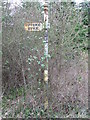
Old Direction Sign
Old pre-Worboys Direction road sign near to Ufford, Suffolk for overall view see http://www.geograph.org.uk/photo/3859893
Image: © Keith Evans
Taken: 23 Feb 2014
0.18 miles
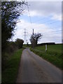
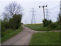
7
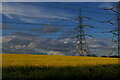
View north towards the pylon lines, Byng Lane
Image: © Christopher Hilton
Taken: 16 May 2021
0.21 miles
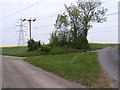
8
Byng Lane
Looking towards the Byng Bridge near the footpath to Stone Hall
Image: © Geographer
Taken: 5 May 2011
0.23 miles
9
Byng Hall Road
At the junction with Hungarian Close
Leading to Hungarian Hall
Image: © Geographer
Taken: 16 Apr 2010
0.25 miles