IMAGES TAKEN NEAR TO
Byng Lane, WOODBRIDGE, IP13 0JE
Introduction
This page details the photographs taken nearby to Byng Lane, IP13 0JE by members of the Geograph project.
The Geograph project started in 2005 with the aim of publishing, organising and preserving representative images for every square kilometre of Great Britain, Ireland and the Isle of Man.

There are currently over 7.5m images from over14,400 individuals and you can help contribute to the project by visiting https://www.geograph.org.uk
Image Map
Images are licensed for reuse under creativecommons.org/licenses/by-sa/2.0
Notes
- Clicking on the map will re-center to the selected point.
- The higher the marker number, the further away the image location is from the centre of the postcode.
Image Listing (27 Images Found)
Images are licensed for reuse under creativecommons.org/licenses/by-sa/2.0
Image
Details
Distance
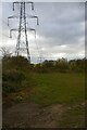
1
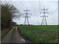
Pylons Over Byng Lane
Pylons and Byng Lane near to Pettistree, Suffolk.
Image: © Keith Evans
Taken: 23 Feb 2014
0.09 miles
3
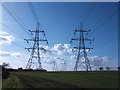
Double line of pylons
Astride the Suffolk countryside.
Image: © Jonathan Billinger
Taken: 8 Mar 2007
0.11 miles
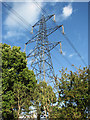
4
Pylon lines crossing Byng Lane
The twin electricity pylon lines seen here carry power from Sizewell B nuclear power station to a point north of Ipswich, from which it feeds into the National Grid.
Image: © Christopher Hilton
Taken: 8 May 2021
0.11 miles

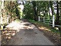
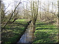
8
Bridge
Bridge over Byng Brook near to Pettistree, Suffolk.
Image: © Keith Evans
Taken: 23 Feb 2014
0.13 miles