IMAGES TAKEN NEAR TO
Presmere Road, WOODBRIDGE, IP13 0JA
Introduction
This page details the photographs taken nearby to Presmere Road, IP13 0JA by members of the Geograph project.
The Geograph project started in 2005 with the aim of publishing, organising and preserving representative images for every square kilometre of Great Britain, Ireland and the Isle of Man.

There are currently over 7.5m images from over14,400 individuals and you can help contribute to the project by visiting https://www.geograph.org.uk
Image Map
Images are licensed for reuse under creativecommons.org/licenses/by-sa/2.0
Notes
- Clicking on the map will re-center to the selected point.
- The higher the marker number, the further away the image location is from the centre of the postcode.
Image Listing (38 Images Found)
Images are licensed for reuse under creativecommons.org/licenses/by-sa/2.0
Image
Details
Distance
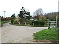
2
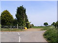
Byng Lane, Pettistree
At the junction with Java Lodge & Presmere Roads
Image: © Geographer
Taken: 6 May 2011
0.10 miles
3
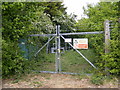
Electricity Sub Station in Java Lodge Road
Image: © Geographer
Taken: 5 May 2011
0.11 miles
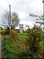
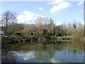
5
Road Junction And Pond
Road junction and pond near to Pettistree, Suffolk.
Image: © Keith Evans
Taken: 23 Feb 2014
0.11 miles
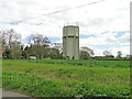
6
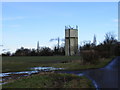
Pettistree Water Tower
Off Presmere Road
Image: © Geographer
Taken: 19 Jan 2009
0.11 miles
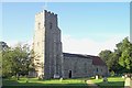
7
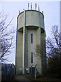
Pettistree Water Tower
Off Presmere Road
Image: © Geographer
Taken: 19 Jan 2009
0.11 miles
8
Pond reflections
The pond is by the junction of Byng Lane and Java Lodge Road near Pettistree.
Image: © Jonathan Billinger
Taken: 8 Mar 2007
0.12 miles
9
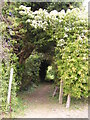
Footpath to Grove Road
Off Java Lodge Road
Image: © Geographer
Taken: 5 May 2011
0.12 miles