IMAGES TAKEN NEAR TO
Hacheston, WOODBRIDGE, IP13 0EY
Introduction
This page details the photographs taken nearby to IP13 0EY by members of the Geograph project.
The Geograph project started in 2005 with the aim of publishing, organising and preserving representative images for every square kilometre of Great Britain, Ireland and the Isle of Man.

There are currently over 7.5m images from over14,400 individuals and you can help contribute to the project by visiting https://www.geograph.org.uk
Image Map
Images are licensed for reuse under creativecommons.org/licenses/by-sa/2.0
Notes
- Clicking on the map will re-center to the selected point.
- The higher the marker number, the further away the image location is from the centre of the postcode.
Image Listing (38 Images Found)
Images are licensed for reuse under creativecommons.org/licenses/by-sa/2.0
Image
Details
Distance
1
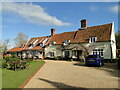
Glevering former mill and millhouse
The left hand end of the main range over the wheelrace, is cased in brick and formed part of the watermill which was demolished circa 1900 and replaced by the single storey brick range extending over the river. This later building housed a waterwheel which pumped water to Glevering Hall. Image
Photographed with the owner's permission.
Image: © Adrian S Pye
Taken: 11 May 2021
0.01 miles
2

Glevering watermill
The left hand end of the main range over the wheelrace, is cased in brick and formed part of the watermill which was demolished circa 1900 and replaced by the single storey brick range extending over the river. This later building housed a waterwheel which pumped water to Glevering Hall. Image
Photographed with the owner's permission.
Image: © Adrian S Pye
Taken: 11 May 2021
0.01 miles
3
Glevering watermill and millhouse
The left hand end of the main range over the wheelrace, is cased in brick and formed part of the watermill which was demolished circa 1900 and replaced by the single storey brick range extending over the river. This later building housed a waterwheel which pumped water to Glevering Hall. Image
Photographed with the owner's permission.
Image: © Adrian S Pye
Taken: 11 May 2021
0.01 miles
4

The millpond at Glevering watermill
https://www.geograph.org.uk/photo/6834781 https://www.geograph.org.uk/photo/6834783
Image: © Adrian S Pye
Taken: 11 May 2021
0.03 miles
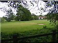
5
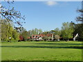
The entrance to Glevering Mill Golf Course
Off the C329
Image: © Geographer
Taken: 16 May 2011
0.04 miles
7
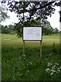
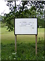
Glevering Mill Golf Course sign
Off the C329
Image: © Geographer
Taken: 16 May 2011
0.05 miles
9
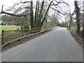
Minor Road
Minor road near to Wickham Market, Suffolk.
Image: © Keith Evans
Taken: 11 Mar 2010
0.06 miles
10
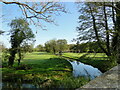
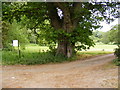
River Deben upstream from Glevering Bridge
A footbridge over the river connects both sides of the river and the parts of the seven green, 9 or 18 hole, 52 par golf course with the mill stream running alongside.
Image: © Adrian S Pye
Taken: 11 May 2021
0.07 miles