IMAGES TAKEN NEAR TO
Beaufort Street, IPSWICH, IP1 2NR
Introduction
This page details the photographs taken nearby to Beaufort Street, IP1 2NR by members of the Geograph project.
The Geograph project started in 2005 with the aim of publishing, organising and preserving representative images for every square kilometre of Great Britain, Ireland and the Isle of Man.

There are currently over 7.5m images from over14,400 individuals and you can help contribute to the project by visiting https://www.geograph.org.uk
Image Map
Images are licensed for reuse under creativecommons.org/licenses/by-sa/2.0
Notes
- Clicking on the map will re-center to the selected point.
- The higher the marker number, the further away the image location is from the centre of the postcode.
Image Listing (38 Images Found)
Images are licensed for reuse under creativecommons.org/licenses/by-sa/2.0
Image
Details
Distance
1
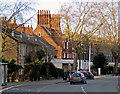
Winter sunlight, Norwich Road
A foreshortened zoom view, concentrating on the sunlit gables and stacks which first caught my eye. The long terrace on the right is Grade II listed - see http://www.britishlistedbuildings.co.uk/en-275538-139-167-norwich-road-suffolk .
Image: © John Sutton
Taken: 10 Jan 2015
0.03 miles
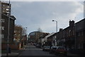
3
Looking down Cumberland Street
Building works were taking place along to the right, with the road closed to vehicles.
Image: © Andrew Hill
Taken: 30 Apr 2009
0.10 miles
5
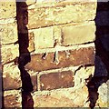
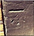
Cut Mark Ipswich 52 / 54 Anglesea Road Gatepost
Cut Mark Ipswich 52 / 54 Anglesea Road Gatepost, cut mark on brick gate post.
Image: © Cud05
Taken: 13 Apr 2016
0.15 miles
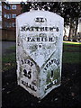
6
To Bury 25
Old cast iron milepost Norwich Road Ipswich, Suffolk on what was the old A45 / A140. For overall view see http://www.geograph.org.uk/photo/1168408 For more info see http://milestones.megalithia.com/sites/tm152454.htm do look at their home page.
Image: © Keith Evans
Taken: 18 Feb 2009
0.16 miles
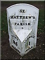
7
Old Milepost by the A5116, Norwich Road, Ipswich
Cast iron plate by the A1156, in parish of IPSWICH (IPSWICH District), Norwich Road, Southeast of junction with Chevallier Street, by the road, on Southwest side of road. Erected by the Hadleigh turnpike trust in the 19th century.
Inscription reads:-
: BURY / 25 / MILES : : ST. MATTHEW'S / PARISH : : IPSWICH / 1 / MILE :
Grade II listed.
List Entry Number: 1236730 https://historicengland.org.uk/listing/the-list/list-entry/1236730
Milestone Society National ID: SU_IWBU01.
Image: © R Mudhar & D Riseborough
Taken: 8 Dec 2010
0.16 miles
8
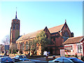
All Saints church in Chevallier Street, Ipswich
Image: © Adrian S Pye
Taken: 12 Jan 2008
0.16 miles
10
Cut Mark Ipswich The Inkerman PH
Cut Mark Ipswich The Inkerman PH SE face, S angle.
Image: © Cud05
Taken: 12 Jun 2017
0.17 miles