IMAGES TAKEN NEAR TO
Little Gipping Street, IPSWICH, IP1 2BT
Introduction
This page details the photographs taken nearby to Little Gipping Street, IP1 2BT by members of the Geograph project.
The Geograph project started in 2005 with the aim of publishing, organising and preserving representative images for every square kilometre of Great Britain, Ireland and the Isle of Man.

There are currently over 7.5m images from over14,400 individuals and you can help contribute to the project by visiting https://www.geograph.org.uk
Image Map
Images are licensed for reuse under creativecommons.org/licenses/by-sa/2.0
Notes
- Clicking on the map will re-center to the selected point.
- The higher the marker number, the further away the image location is from the centre of the postcode.
Image Listing (451 Images Found)
Images are licensed for reuse under creativecommons.org/licenses/by-sa/2.0
Image
Details
Distance
1
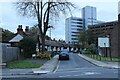
View of a curved terrace of cottages on Canham Street from Portman Road
Looking east-northeast.
Image: © Robert Lamb
Taken: 6 Nov 2021
0.03 miles
2
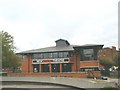
Wolsey Theatre
Modern semi- in the round theatre showing plays, musicals and pantomime in Ipswich.
Image: © michael wade
Taken: 1 Jun 2005
0.04 miles
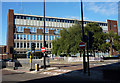
3
Handford Road, Ipswich
Looking towards the council building.
Image: © David Howard
Taken: 22 May 2022
0.04 miles
4
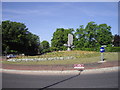
The Ship sculpture by Bernard Reynolds
Made of aluminium, steel and fibre-glass in 1971 this sculpture is on the Civic Drive Roundabout
Image: © PAUL FARMER
Taken: 22 May 2010
0.05 miles
5
The end of the A1071
The A1071 ends at this roundabout (A1022, Civic Drive). Ahead just goes to the spiral car park. The other end of the A1071 is near Newton http://www.geograph.org.uk/photo/3701604, though the A1071 does go through the A1214.
Image: © Hamish Griffin
Taken: 5 Mar 2014
0.05 miles
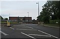
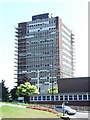
6
Civic Drive and Suffolk Constabulary Ipswich Divisional Headquarters
Looking across Civic Drive. The magistrates court and crown court are both nearby.
Image: © Andrew Hill
Taken: 31 Aug 2009
0.05 miles
7
Coming down
The former Ipswich Borough offices slowly being demolished Ipswich Suffolk. See http://www.geograph.org.uk/photo/553812 for view of its former self. For view seven months later see http://www.geograph.org.uk/photo/1181171
Image: © Keith Evans
Taken: 24 Jul 2008
0.05 miles
8

Looking over the Spiral car park towards Civic Drive
Below these concrete curves the Spiral car park descends into the earth; around it, surface car parks and the inner ring road. The 1960s were not kind to this corner of Ipswich.
Image: © Christopher Hilton
Taken: 5 Aug 2017
0.06 miles
9
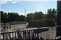
Looking from the Spiral car park towards Civic Drive
The first match of the season had just ended at Portman Road (Ipswich Town 1, Birmingham City 0) and crowds in replica shirts had made their way up the hill to pay for the parking and reclaim their cars. Civic Drive and the other roads around rapidly seized up with match-day traffic.
Image: © Christopher Hilton
Taken: 5 Aug 2017
0.06 miles
10
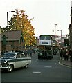
Once a familiar sight ? 1971
The sight of queues of buses to take supporters home from football matches was common in times past. Changes to legislation following the deregulation of services in 1986 made it virtually impossible for operators to provide such services on an ad hoc basis. This was the scene after a match at Ipswich Town F C's Portman Road ground with Ipswich Corporation buses departing to various parts of the town.
This is one of a series of views featuring buses in the 60s, 70s, and 80s. http://www.geograph.org.uk/search.php?i=137652761
Image: © Alan Murray-Rust
Taken: 23 Apr 1971
0.07 miles