IMAGES TAKEN NEAR TO
Firmin Close, IPSWICH, IP1 2BF
Introduction
This page details the photographs taken nearby to Firmin Close, IP1 2BF by members of the Geograph project.
The Geograph project started in 2005 with the aim of publishing, organising and preserving representative images for every square kilometre of Great Britain, Ireland and the Isle of Man.

There are currently over 7.5m images from over14,400 individuals and you can help contribute to the project by visiting https://www.geograph.org.uk
Image Map
Images are licensed for reuse under creativecommons.org/licenses/by-sa/2.0
Notes
- Clicking on the map will re-center to the selected point.
- The higher the marker number, the further away the image location is from the centre of the postcode.
Image Listing (202 Images Found)
Images are licensed for reuse under creativecommons.org/licenses/by-sa/2.0
Image
Details
Distance
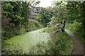
3
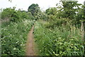
Footpath alongside the disused Alderman canal
Image: © Oxymoron
Taken: 14 May 2009
0.08 miles
6
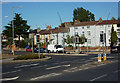
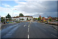
Houses on London Road
London Road becomes narrow and unsuitable for large amounts of traffic, so is no longer a significant route into town from this point onwards.
Image: © Andrew Hill
Taken: 31 Aug 2009
0.10 miles
9
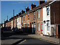
Elliott Street, Ipswich
A street of terraced houses off Handford Road.
Image: © Andrew Hill
Taken: 31 Aug 2009
0.10 miles
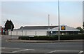
10
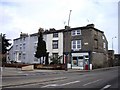
Former sub Post Office Mile End Ipswich
Located at the junction of London and Handwood Roads
Image: © PAUL FARMER
Taken: 21 Nov 2009
0.10 miles