IMAGES TAKEN NEAR TO
Sandy Lane, WOODBRIDGE, IP12 4SD
Introduction
This page details the photographs taken nearby to Sandy Lane, IP12 4SD by members of the Geograph project.
The Geograph project started in 2005 with the aim of publishing, organising and preserving representative images for every square kilometre of Great Britain, Ireland and the Isle of Man.

There are currently over 7.5m images from over14,400 individuals and you can help contribute to the project by visiting https://www.geograph.org.uk
Image Map
Images are licensed for reuse under creativecommons.org/licenses/by-sa/2.0
Notes
- Clicking on the map will re-center to the selected point.
- The higher the marker number, the further away the image location is from the centre of the postcode.
Image Listing (47 Images Found)
Images are licensed for reuse under creativecommons.org/licenses/by-sa/2.0
Image
Details
Distance

2
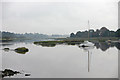
Martlesham Creek
Western end, looking east, on a typical atmospheric day.
Image: © Andy Stephenson
Taken: 16 Oct 2004
0.05 miles

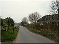
7
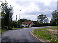
Sandy Lane, Martlesham
At the junction with The Street, Martlesham
Image: © Geographer
Taken: 5 Aug 2011
0.15 miles
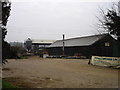
8
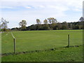
Martlesham Recreation Ground
Off Top Street
Image: © Geographer
Taken: 25 Oct 2008
0.16 miles
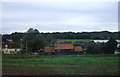
9
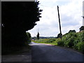
Sandy Lane, Woodbridge
Looking towards Martlesham near to the Sewage Treatment Plant
Image: © Geographer
Taken: 5 Aug 2011
0.16 miles
10
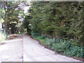
Footpath to Waldringfield Road & entrance to Woodbridge Sewage Treatment Works
Off Sandy Lane
Image: © Geographer
Taken: 5 Aug 2011
0.16 miles