IMAGES TAKEN NEAR TO
Fishpond Road, WOODBRIDGE, IP12 4QX
Introduction
This page details the photographs taken nearby to Fishpond Road, IP12 4QX by members of the Geograph project.
The Geograph project started in 2005 with the aim of publishing, organising and preserving representative images for every square kilometre of Great Britain, Ireland and the Isle of Man.

There are currently over 7.5m images from over14,400 individuals and you can help contribute to the project by visiting https://www.geograph.org.uk
Image Map
Images are licensed for reuse under creativecommons.org/licenses/by-sa/2.0
Notes
- Clicking on the map will re-center to the selected point.
- The higher the marker number, the further away the image location is from the centre of the postcode.
Image Listing (64 Images Found)
Images are licensed for reuse under creativecommons.org/licenses/by-sa/2.0
Image
Details
Distance
1
Waldringfield: towards Dairy Farm House
Fishpond Road on the afternoon of Christmas Day. The house dates from the late 17th century and is Grade II listed.
Image: © John Sutton
Taken: 25 Dec 2019
0.02 miles
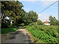
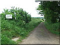
2
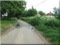
Fishpond Road
Looking north east along Fishpond road Waldringfield, Suffolk.
Image: © Keith Evans
Taken: 22 May 2014
0.02 miles
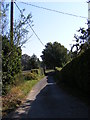
3
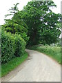
Bend On Country Lane
Bend on Fishpond Road Waldringfield, Suffolk.
Image: © Keith Evans
Taken: 22 May 2014
0.03 miles
4
Waldringfield: on Fishpond Road
This 17th-century Grade II listed house was originally two cottages.
Image: © John Sutton
Taken: 23 Aug 2018
0.03 miles
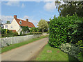
5
Waldringfield: on Fishpond Road in August
At the northern edge of the village.
Image: © John Sutton
Taken: 23 Aug 2018
0.04 miles
6
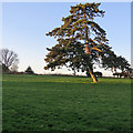
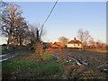
Waldringfield: afternoon sunlight on Christmas Day
A field north of Fishpond Road at three o'clock on Christmas afternoon.
Image: © John Sutton
Taken: 25 Dec 2019
0.05 miles
7
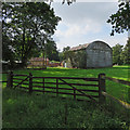
Waldringfield: outbuildings at Rivers Hall
A view from Fishpond Road, taken on an August afternoon.
Image: © John Sutton
Taken: 23 Aug 2018
0.05 miles
8
Sandy Lane, Waldringfield
Looking towards Cliff Road near the bridleway
Image: © Geographer
Taken: 30 Sep 2011
0.06 miles
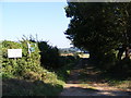
9
Footpath Only
Private road footpath only leading to the River Deben near to Waldringfield, Suffolk.
Image: © Keith Evans
Taken: 22 May 2014
0.07 miles
10
Bridleway to the River Deben & Waldringfield
Off Fish Pond Road
Image: © Geographer
Taken: 30 Sep 2011
0.08 miles