IMAGES TAKEN NEAR TO
Sullivan Place, WOODBRIDGE, IP12 4QT
Introduction
This page details the photographs taken nearby to Sullivan Place, IP12 4QT by members of the Geograph project.
The Geograph project started in 2005 with the aim of publishing, organising and preserving representative images for every square kilometre of Great Britain, Ireland and the Isle of Man.

There are currently over 7.5m images from over14,400 individuals and you can help contribute to the project by visiting https://www.geograph.org.uk
Image Map
Images are licensed for reuse under creativecommons.org/licenses/by-sa/2.0
Notes
- Clicking on the map will re-center to the selected point.
- The higher the marker number, the further away the image location is from the centre of the postcode.
Image Listing (91 Images Found)
Images are licensed for reuse under creativecommons.org/licenses/by-sa/2.0
Image
Details
Distance
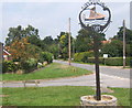
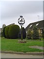
1
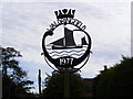
Waldringfield Village Sign
Off School Road at the junction with Sullivan Place
(Close up)
Image: © Geographer
Taken: 25 Oct 2008
0.02 miles
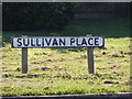
2
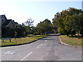
Sullivan Place, Waldringfield
At the junction with School Road
Image: © Geographer
Taken: 30 Sep 2011
0.02 miles
3
Waldringfield Village Sign
Off School Road at the junction with Sullivan Place
Image: © Geographer
Taken: 25 Oct 2008
0.03 miles
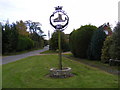
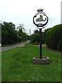
4
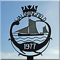
Waldringfield village sign
The sign was erected along with many others in 1977 for the Queen’s silver jubilee. It is surmounted by a crown to celebrate the occasion and has a silhouette of a ketch, a reference to the local sailing club and close proximity of the River Deben. https://www.geograph.org.uk/photo/4295649
Image: © Adrian S Pye
Taken: 10 Mar 2015
0.03 miles
5
Waldringfield village sign, looking north along School Road
Walking through this part of the village, one would be forgiven for questioning the reference to boats and water on the village sign. The estuary of the Deben River is hidden away to the east.
Image: © Andrew Hill
Taken: 23 Jul 2008
0.03 miles
6
Sullivan Place sign
At the junction with School Road
Image: © Geographer
Taken: 30 Sep 2011
0.03 miles
8
Village Sign
Village sign at Waldringfield, Suffolk. For close up view see http://www.geograph.org.uk/photo/4052676
Image: © Keith Evans
Taken: 22 May 2014
0.03 miles
9

Waldringfield Sign
Close up of the village sign at Waldringfield, Suffolk for an overall view see http://www.geograph.org.uk/photo/4052671
Image: © Keith Evans
Taken: 22 May 2014
0.03 miles
10
Waldringfield village sign
The sign was erected along with many others in 1977 for the Queen’s silver jubilee. It is surmounted by a crown to celebrate the occasion and has a silhouette of a ketch, a reference to the local sailing club and close proximity of the River Deben. https://www.geograph.org.uk/photo/6783544
Image: © Adrian S Pye
Taken: 18 Apr 2007
0.03 miles