IMAGES TAKEN NEAR TO
Waldringfield Road, WOODBRIDGE, IP12 4PJ
Introduction
This page details the photographs taken nearby to Waldringfield Road, IP12 4PJ by members of the Geograph project.
The Geograph project started in 2005 with the aim of publishing, organising and preserving representative images for every square kilometre of Great Britain, Ireland and the Isle of Man.

There are currently over 7.5m images from over14,400 individuals and you can help contribute to the project by visiting https://www.geograph.org.uk
Image Map
Images are licensed for reuse under creativecommons.org/licenses/by-sa/2.0
Notes
- Clicking on the map will re-center to the selected point.
- The higher the marker number, the further away the image location is from the centre of the postcode.
Image Listing (11 Images Found)
Images are licensed for reuse under creativecommons.org/licenses/by-sa/2.0
Image
Details
Distance
1
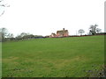
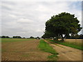
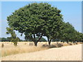
Howe's Farm
Part of Howe's farm near to Waldringfield Suffolk
Image: © Keith Evans
Taken: 30 Jan 2007
0.01 miles
2
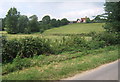
View towards Howe's Farm from Waldringfield Road
Image: © Andrew Hill
Taken: 23 Jul 2008
0.03 miles
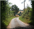
3
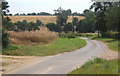
Waldringfield Road descending beyond the turn for Howe's Farm
Image: © Andrew Hill
Taken: 23 Jul 2008
0.06 miles
4
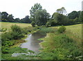
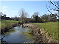
Little valley with pool seen from Waldringfield Road
Image: © Andrew Hill
Taken: 23 Jul 2008
0.09 miles
6
Waldringfield Road emerging from trees
Looking southeast just before descending to the little valley near Howe's Farm.
Image: © Andrew Hill
Taken: 23 Jul 2008
0.11 miles
10
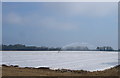
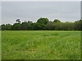
Watering the plastic
Presumably the membrane is porous, otherwise the exercise seems a bit pointless.
Image: © Oxymoron
Taken: 21 Apr 2009
0.22 miles