IMAGES TAKEN NEAR TO
Lower Haugh Lane, WOODBRIDGE, IP12 4NJ
Introduction
This page details the photographs taken nearby to Lower Haugh Lane, IP12 4NJ by members of the Geograph project.
The Geograph project started in 2005 with the aim of publishing, organising and preserving representative images for every square kilometre of Great Britain, Ireland and the Isle of Man.

There are currently over 7.5m images from over14,400 individuals and you can help contribute to the project by visiting https://www.geograph.org.uk
Image Map
Images are licensed for reuse under creativecommons.org/licenses/by-sa/2.0
Notes
- Clicking on the map will re-center to the selected point.
- The higher the marker number, the further away the image location is from the centre of the postcode.
Image Listing (46 Images Found)
Images are licensed for reuse under creativecommons.org/licenses/by-sa/2.0
Image
Details
Distance
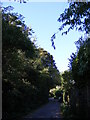
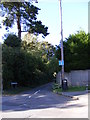
4
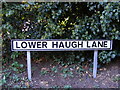
Lower Haugh Lane sign
On Lower Haugh Lane at the junction with North Hill, Bredfield & Castle Streets
Image: © Geographer
Taken: 12 Sep 2011
0.07 miles
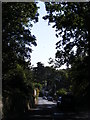
5
Lower Haugh Lane, Woodbridge
At the junction with Bredfield Street
Image: © Geographer
Taken: 12 Sep 2011
0.08 miles
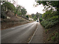
6
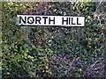
North Hill sign
On North Hill At the junction with Woolnough, Pytches & Bredfield Road
Image: © Geographer
Taken: 12 Sep 2011
0.08 miles
7
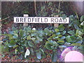
Bredfield Road sign
On Bredfield Road at the junction with Woolnough Road, North Hill & Pytches Road
Image: © Geographer
Taken: 12 Sep 2011
0.09 miles
8
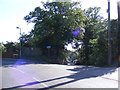
Pytches Road, Melton
At the junction with North Hill
Image: © Geographer
Taken: 12 Sep 2011
0.09 miles
10
Cottages in Bredfield Road, Woodbridge
Image: © Evelyn Simak
Taken: 18 Oct 2011
0.11 miles