IMAGES TAKEN NEAR TO
Otley Road, WOODBRIDGE, IP12 3TN
Introduction
This page details the photographs taken nearby to Otley Road, IP12 3TN by members of the Geograph project.
The Geograph project started in 2005 with the aim of publishing, organising and preserving representative images for every square kilometre of Great Britain, Ireland and the Isle of Man.

There are currently over 7.5m images from over14,400 individuals and you can help contribute to the project by visiting https://www.geograph.org.uk
Image Map
Images are licensed for reuse under creativecommons.org/licenses/by-sa/2.0
Notes
- Clicking on the map will re-center to the selected point.
- The higher the marker number, the further away the image location is from the centre of the postcode.
Image Listing (16 Images Found)
Images are licensed for reuse under creativecommons.org/licenses/by-sa/2.0
Image
Details
Distance
1
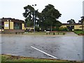
Sandlings Primary School
Sandlings C.P. Primary School, on the site of RAF Woodbridge
Image: © Claire Haystead
Taken: 13 May 2007
0.10 miles
2
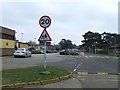
School Zone
School zone outside Sandlings primary school on the former U.S.A.F. Woodbridge airbase near to Sutton Heath Estate, Suffolk.
Image: © Keith Evans
Taken: 19 Mar 2015
0.10 miles
4
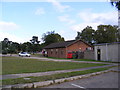
Rock Barracks entrance
Home of the 23 Parachute Engineer Regiment
Image: © Adrian S Pye
Taken: 30 Oct 2020
0.14 miles
5

Telephone Box & RAF Camp Postbox
Postbox No.IP12 6371
Image: © Geographer
Taken: 26 Sep 2011
0.15 miles
6

Telephone Box & RAF Camp Postbox
Postbox No.IP12 6371
Image: © Geographer
Taken: 26 Sep 2011
0.15 miles
7

Telephone Box & RAF Camp Postbox
Postbox No.IP12 6371
Image: © Geographer
Taken: 26 Sep 2011
0.15 miles

9

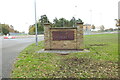
Friston Road, Woodbridge
At the junction with Otley Road
Image: © Geographer
Taken: 26 Sep 2011
0.16 miles
