IMAGES TAKEN NEAR TO
Bawdsey, WOODBRIDGE, IP12 3BH
Introduction
This page details the photographs taken nearby to IP12 3BH by members of the Geograph project.
The Geograph project started in 2005 with the aim of publishing, organising and preserving representative images for every square kilometre of Great Britain, Ireland and the Isle of Man.

There are currently over 7.5m images from over14,400 individuals and you can help contribute to the project by visiting https://www.geograph.org.uk
Image Map
Images are licensed for reuse under creativecommons.org/licenses/by-sa/2.0
Notes
- Clicking on the map will re-center to the selected point.
- The higher the marker number, the further away the image location is from the centre of the postcode.
Image Listing (23 Images Found)
Images are licensed for reuse under creativecommons.org/licenses/by-sa/2.0
Image
Details
Distance
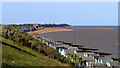
1
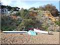
Steps down to the sea
Adjacent to the Bawdsey Manor estate.
Image: © Patrick Mackie
Taken: 1 Apr 2011
0.07 miles
2
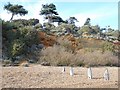
Cliffs near Badwsey Manor
Soft sandstones, easily eroded by the sea. The high shingle bank provides some protection from the waves.
Image: © Patrick Mackie
Taken: 1 Apr 2011
0.08 miles
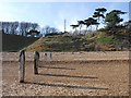
3
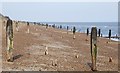
A forest of groynes
Rows of posts disappearing into the distance.
Image: © Patrick Mackie
Taken: 1 Apr 2011
0.14 miles
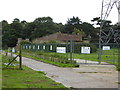
4
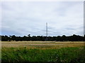
Looking towards the mast from Ferry Road
The Transmitter Block Museum is near the base of the mast https://www.bawdseyradar.org.uk/
Image: © Chris Holifield
Taken: 27 Jul 2020
0.14 miles
5
Radio Mast, Bawdsey
Taken from Ferry Road, on to which the Suffolk Coast path has been diverted at the moment due to coastal erosion.
Image: © Trevor Harris
Taken: 21 Jul 2013
0.15 miles
6
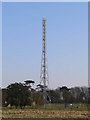
Radio mast
The last surviving mast of the original Bawdsey 'Chain Home' radar station, although now carrying modern equipment that may be associated with the coastguard - the circular VHF direction-finding aerial on top is characteristic of HM coastguard stations.
Image: © Richard Mudhar
Taken: 25 Mar 2007
0.15 miles
7
Shingle beach and cliffs
The MCGA mast at Bawdsey in the distance.
Image: © Patrick Mackie
Taken: 1 Apr 2011
0.16 miles
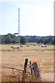
9
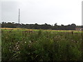
Fields and radio transmitter near Bawdsey
Image: © Helen Steed
Taken: 7 Aug 2011
0.18 miles
10
Bawdsey and the Deben Haven From Brackenbury, Felixstowe
Photo taken from near to the site of the WW1, WW2 coastal defence battery of Brackenbury Fort.
https://en.wikipedia.org/wiki/Brackenbury_Battery
View north east up the coast to:
2. Walton Castle
https://www.geograph.org.uk/photo/2415620
A Roman era Saxon Shore Fort, built between AD 276-285 and stood circa 30 metres above sea level before being destroyed by sea erosion in the 18th century.
https://en.wikipedia.org/wiki/Walton_Castle,_Suffolk
Beyond the site of the castle are the shoals at the mouth of the Deben which shift continuously and ...
2. Martello Tower T
https://www.geograph.org.uk/photo/353802
The golf links in which the Martello Tower stands were the site of Operation Outward, a British World War II program to attack Germany by means of free-flying balloons. A total of 99,142 Outward balloons were launched; about half carried incendiaries and half carried trailing wires.
https://en.wikipedia.org/wiki/Operation_Outward
2. Bawdsey Manor
https://www.geograph.org.uk/photo/62110
Immediately behind Tower T is Bawdsey Manor purchased by the Air Ministry in 1936 to establish a research station for developing the Chain Home RDF (radar) system. RAF Bawdsey was a base through the Cold War until the 1990s. A remaining radar mast can be seen on the skyline to the right of the manor house. There is radar museum in the manor grounds https://www.bawdseyradar.org.uk/
3. Orfordness Lighthouse
https://www.geograph.org.uk/photo/2600984
To the right of the headland at Bawdsey on the skyline the lighthouse is visbible. It was demolished in July 2020, just after this picture was taken. To the left of the lighthouse are various of the buildings including the Atomic Weapons Research Establishment on the Ness. The Radar Tower is identifiable. https://www.geograph.org.uk/photo/287811
Until I got this picture home and could blow the picture up to full size I did not know that I had a photo of the lighthouse and I had not been aware that it even was possible to see it up the coast past Bawdsey.
Image: © Tim Marchant
Taken: 31 May 2020
0.18 miles