1
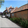
High Street
Not the busiest high street in the country but charming for all that.
Image: © Stuart Logan
Taken: 25 Jun 2013
0.01 miles
2
High Street and Doctor's Lane, Orford
Houses on the edge of the village of Orford
Image: © David Smith
Taken: 15 Jun 2014
0.03 miles
3
Orford: along Doctor's Lane
Looking towards Rectory Road on an August afternoon.
Image: © John Sutton
Taken: 2 Aug 2019
0.03 miles
4
Orford old fire station
Orford old fire station, Rectory Road, Orford, Suffolk, undergoing conversion to a dwelling
Image: © Kevin Hale
Taken: 5 Jun 2010
0.04 miles
5
Orford: High Street cottages
Old and new pantiles on a sunny April afternoon.
Image: © John Sutton
Taken: 11 Apr 2017
0.04 miles
6
Churchyard of St Bartholomew's parish church, Orford
The churchyard of St Bartholomew's is large and extends some way north of the church: here, a public footpath passes through the grass and out through the northern boundary.
Image: © Christopher Hilton
Taken: 12 Jul 2020
0.07 miles
7
Churchyard, St Bartholomew's Church, Orford
The northern area of the churchyard looking north east.
Image: © Trevor Harris
Taken: 22 Aug 2022
0.08 miles
8
Orford: High Street pantiles
Typical Suffolk vernacular architecture, photographed on an August afternoon.
Image: © John Sutton
Taken: 2 Aug 2019
0.09 miles
9
Ruins in St. Bartholomew's Churchyard, Orford
Image: © Kim Fyson
Taken: 12 Aug 2014
0.09 miles
10
Orford village panorama, including church, from the castle
The towers of the BBC Radio World Service are just detectable in the mist on the original photo, on the peninsula beyond the river to the left of the church tower. Before the BBC took on the site it was occupied by the massive and massively expensive USAF 'Cobra Mist' over-the-horizon experimental radar, which was abandoned when high noise levels stopped it working well enough to be any use. See http://en.wikipedia.org/wiki/Cobra_Mist. A look at Google Earth will still reveal the fan shaped layout of that huge aerial array.
Image: © John Goldsmith
Taken: 9 Apr 2007
0.09 miles


