IMAGES TAKEN NEAR TO
Ufford Road, WOODBRIDGE, IP12 2QB
Introduction
This page details the photographs taken nearby to Ufford Road, IP12 2QB by members of the Geograph project.
The Geograph project started in 2005 with the aim of publishing, organising and preserving representative images for every square kilometre of Great Britain, Ireland and the Isle of Man.

There are currently over 7.5m images from over14,400 individuals and you can help contribute to the project by visiting https://www.geograph.org.uk
Image Map
Images are licensed for reuse under creativecommons.org/licenses/by-sa/2.0
Notes
- Clicking on the map will re-center to the selected point.
- The higher the marker number, the further away the image location is from the centre of the postcode.
Image Listing (40 Images Found)
Images are licensed for reuse under creativecommons.org/licenses/by-sa/2.0
Image
Details
Distance

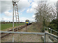
4
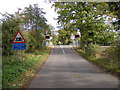
Bridge Street Level Crossing
Looking towards the A1152 Eyke Road
Image: © Geographer
Taken: 25 Oct 2008
0.01 miles
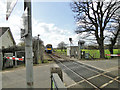
5
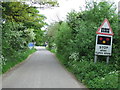
Level Crossing Ahead
Approaching Bridge Road level crossing near to Ufford, Suffolk.
Image: © Keith Evans
Taken: 11 May 2014
0.01 miles
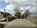
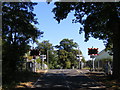
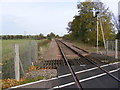
7
Ufford Level Crossing
Level crossing on a minor road near Bromeswell
Image: © Richard Mudhar
Taken: 26 Mar 2007
0.02 miles
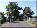
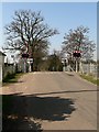
8
Bridge Street Level Crossing
Looking towards Wickham Market
Image: © Geographer
Taken: 25 Oct 2008
0.03 miles