IMAGES TAKEN NEAR TO
Bromeswell, WOODBRIDGE, IP12 2PF
Introduction
This page details the photographs taken nearby to IP12 2PF by members of the Geograph project.
The Geograph project started in 2005 with the aim of publishing, organising and preserving representative images for every square kilometre of Great Britain, Ireland and the Isle of Man.

There are currently over 7.5m images from over14,400 individuals and you can help contribute to the project by visiting https://www.geograph.org.uk
Image Map
Images are licensed for reuse under creativecommons.org/licenses/by-sa/2.0
Notes
- Clicking on the map will re-center to the selected point.
- The higher the marker number, the further away the image location is from the centre of the postcode.
Image Listing (29 Images Found)
Images are licensed for reuse under creativecommons.org/licenses/by-sa/2.0
Image
Details
Distance
2
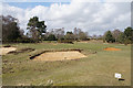
Hexagonal FW3/22 pillbox on Woodbridge golf course
Only the roof can be seen as it is surrounded by bracken and brambles. The pillbox faces east and the entrance is immediately in front of the camera.
Image: © Adrian S Pye
Taken: 11 Oct 2014
0.15 miles
3
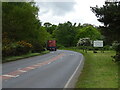
Woodbridge Golf Club
The footpath needs to cross at least 3 fairways.
Image: © Bill Boaden
Taken: 23 Mar 2018
0.19 miles
5
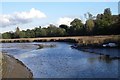
The Marshes at Bromeswell.
Phragmites marsh beside the river Deben at Bromeswell, the nearest bird is a little egret.
Image: © Simon Leatherdale
Taken: 20 Oct 2006
0.21 miles
6
World War II Pillbox near Wilford Bridge
This pillbox almost hidden in trees just across Wilford Bridge from Melton must have covered the bridge and stood guard at an important road junction. To the right the road led to RAF Bawdsey and RAF Woodbridge and to the left is the road to RAF Bentwaters and the coast. Today it just carries a sign pointing to the golf club.
Image: © Chris Holifield
Taken: 2 Jun 2010
0.21 miles
8
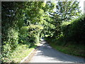
Bridleway to the B1083 & Entrance to Bowfield Old Farm
Off the A1084 Woodbridge Road & Sandy Lane
Image: © Geographer
Taken: 3 Aug 2011
0.22 miles
9
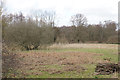
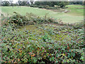
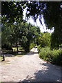
Bromeswell Green Nature Reserve
The south eastern corner of the nature reserve.
Image: © Bill Boaden
Taken: 23 Mar 2018
0.22 miles
10
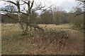
Bromeswell Green Nature Reserve
The nature reserve is managed by Suffolk Wildlife Trust. It is with the permission of Pubmaster Ltd that you can enter it here, having crossed land adjoining the Unruly Pig pub.
Image: © Bill Boaden
Taken: 23 Mar 2018
0.22 miles