IMAGES TAKEN NEAR TO
School Lane, WOODBRIDGE, IP12 2LU
Introduction
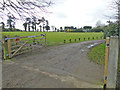
This page details the photographs taken nearby to School Lane, IP12 2LU by members of the Geograph project.
The Geograph project started in 2005 with the aim of publishing, organising and preserving representative images for every square kilometre of Great Britain, Ireland and the Isle of Man.

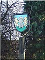
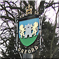
There are currently over 7.5m images from over14,400 individuals and you can help contribute to the project by visiting https://www.geograph.org.uk
Image Map
Images are licensed for reuse under creativecommons.org/licenses/by-sa/2.0
Notes
- Clicking on the map will re-center to the selected point.
- The higher the marker number, the further away the image location is from the centre of the postcode.
Image Listing (348 Images Found)
Images are licensed for reuse under creativecommons.org/licenses/by-sa/2.0
Image
Details
Distance
1
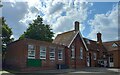
Orford, primary school
There is a benchmark cut into the south-east facing wall of the village primary school.
Image: © Mel Towler
Taken: 5 Jul 2022
0.01 miles
2
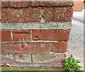
Orford, primary school
The benchmark is cut into the south-east facing wall of the village primary school.
Image: © Mel Towler
Taken: 5 Jul 2022
0.02 miles
3
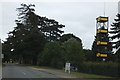
Hose tower at Orford fire station
Ipswich Road into Orford passes the fire station and then the primary school. The sign on the left warns that motorists are entering the School Safety Zone
Image: © David Smith
Taken: 15 Jun 2014
0.02 miles
4
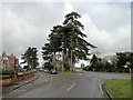
Near the school looking towards the fire station, Orford
Image: © Adrian S Pye
Taken: 25 Feb 2015
0.02 miles
5
Orford village sign
The sign depicts the castle, supported by two lions rampant, the keep of which is a famous landmark. The date 1579 refers to the granting of a charter which incorporated the town as a free borough with a common seal and with power to hold property and to hold a court.
Image: © Adrian S Pye
Taken: 2 Mar 2007
0.03 miles
6
Orford town sign (detail)
The sign depicts the castle, supported by two lions rampant, the keep of which is a famous landmark. The date 1579 refers to the granting of a charter which incorporated the town as a free borough with a common seal and with power to hold property and to hold a court. https://www.geograph.org.uk/photo/4361607
Image: © Adrian S Pye
Taken: 25 Feb 2015
0.03 miles
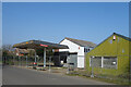
8
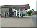
Petrol Station
Petrol station at Orford, Suffolk.
Image: © Keith Evans
Taken: 14 May 2015
0.05 miles
9

Orford fire station
Orford fire station, Ipswich Road, Orford, Suffolk
Image: © Kevin Hale
Taken: 5 Jun 2010
0.06 miles
10
Closed Garage, Front Street
Orford's filling station has pumped its last. Another closed business.
Image: © Des Blenkinsopp
Taken: 24 Mar 2022
0.07 miles