IMAGES TAKEN NEAR TO
Snape Road, WOODBRIDGE, IP12 2JL
Introduction
This page details the photographs taken nearby to Snape Road, IP12 2JL by members of the Geograph project.
The Geograph project started in 2005 with the aim of publishing, organising and preserving representative images for every square kilometre of Great Britain, Ireland and the Isle of Man.

There are currently over 7.5m images from over14,400 individuals and you can help contribute to the project by visiting https://www.geograph.org.uk
Image Map
Images are licensed for reuse under creativecommons.org/licenses/by-sa/2.0
Notes
- Clicking on the map will re-center to the selected point.
- The higher the marker number, the further away the image location is from the centre of the postcode.
Image Listing (98 Images Found)
Images are licensed for reuse under creativecommons.org/licenses/by-sa/2.0
Image
Details
Distance
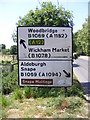
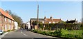
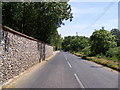
1
Houses on Snape Road (B1069) in Tunstall
These buildings are to the north of the junction with Orford Road (B1078)
Image: © David Smith
Taken: 15 Jun 2014
0.01 miles
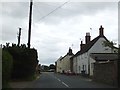
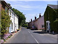
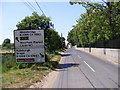
2
B1069 Snape Road
At the junction with the B1078 Orford Road
Image: © Geographer
Taken: 23 May 2011
0.01 miles
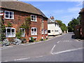
3
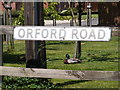
Orford Road sign
On the B1078 Orford Road at the junction with the B1069 Snape Road
Image: © Geographer
Taken: 23 May 2011
0.02 miles
7
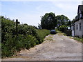
Footpath to the B1069 Woodbridge Road
Off the B1078 Orford Road
Image: © Geographer
Taken: 23 May 2011
0.06 miles
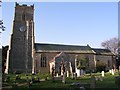
8
B1078 Orford Road, Tunstall
Looking towards St.Michael's Church near the footpath to the B1069 Woodbridge Road
Image: © Geographer
Taken: 23 May 2011
0.07 miles
9
B1078 Orford Road & Roadsign
Looking towards Tunstall
Image: © Geographer
Taken: 23 May 2011
0.07 miles