IMAGES TAKEN NEAR TO
High Street, WOODBRIDGE, IP12 2EY
Introduction
This page details the photographs taken nearby to High Street, IP12 2EY by members of the Geograph project.
The Geograph project started in 2005 with the aim of publishing, organising and preserving representative images for every square kilometre of Great Britain, Ireland and the Isle of Man.

There are currently over 7.5m images from over14,400 individuals and you can help contribute to the project by visiting https://www.geograph.org.uk
Image Map
Images are licensed for reuse under creativecommons.org/licenses/by-sa/2.0
Notes
- Clicking on the map will re-center to the selected point.
- The higher the marker number, the further away the image location is from the centre of the postcode.
Image Listing (15 Images Found)
Images are licensed for reuse under creativecommons.org/licenses/by-sa/2.0
Image
Details
Distance
1
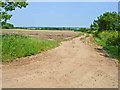
Field near High Street, Iken
The Long Reach of the Alde Estuary can be seen in the background.
Image: © Oliver Dixon
Taken: 7 Jun 2006
0.12 miles
3
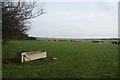
Footpath at High Street
The path follows the line of trees towards the River Alde. High Street is a small hamlet consisting of half a dozen houses.
Image: © Bob Jones
Taken: 22 Jan 2008
0.14 miles
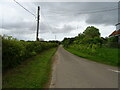
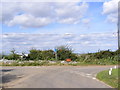
4
Road to Stanny House Farm at High Street
Image: © Geographer
Taken: 19 Sep 2011
0.15 miles
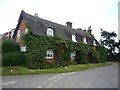
5
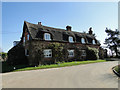
Thatched Cottage at High Street, Iken
The cottage sits at the head of the road that leads to Stanny House Farm, previously Brickkiln Farm in the 19th Century and then Poplar Farm in the 20th Century.
Image: © Simon Mortimer
Taken: 24 Jul 2013
0.16 miles
6
Large thatched house on Poplar Farm Road, Iken
Image: © Adrian S Pye
Taken: 7 Mar 2011
0.16 miles
7

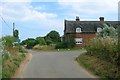
Corner house on Ferry Road, High Street
Image: © Neil Theasby
Taken: 6 Sep 2018
0.16 miles
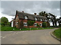
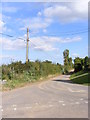
10
Cottage at High Street
On a junction on Ferry Road.
Image: © DS Pugh
Taken: 29 Jul 2012
0.16 miles