IMAGES TAKEN NEAR TO
Langham Road, WOODBRIDGE, IP12 2EF
Introduction
This page details the photographs taken nearby to Langham Road, IP12 2EF by members of the Geograph project.
The Geograph project started in 2005 with the aim of publishing, organising and preserving representative images for every square kilometre of Great Britain, Ireland and the Isle of Man.

There are currently over 7.5m images from over14,400 individuals and you can help contribute to the project by visiting https://www.geograph.org.uk
Image Map
Images are licensed for reuse under creativecommons.org/licenses/by-sa/2.0
Notes
- Clicking on the map will re-center to the selected point.
- The higher the marker number, the further away the image location is from the centre of the postcode.
Image Listing (6 Images Found)
Images are licensed for reuse under creativecommons.org/licenses/by-sa/2.0
Image
Details
Distance
1
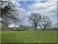
View across grassland to artist's studio
Looking south across a pasture towards the grove that gave Grove Farm its name, we can see a building originally constructed as a Victorian artist's studio.
Image: © Zorba the Geek
Taken: 23 Jan 2009
0.09 miles
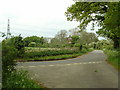
2
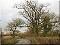
Junction near Langham Bridge
Langham Bridge and Burnt House Farm are to the left, Grove Farm is behind and to the right is Acorn Cottage, along Langham Road. Image is a view of the same junction taken from the road to the right, facing north.
Image: © Zorba the Geek
Taken: 23 Jan 2009
0.10 miles
3
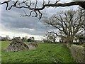
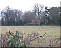
Bare branches and dead wood near Grove Farm
Image: © Simon Mortimer
Taken: 13 Apr 2022
0.10 miles
4
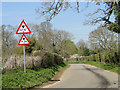
Langham Lane
Looking North West at road junction and road signs warning of height restriction atrailway bridge half a mile away. Also electricity pylon in the distance.
Image: © Claire Haystead
Taken: 6 May 2007
0.12 miles
5
Height restriction in Imperial and Metric
Image: © Adrian S Pye
Taken: 21 Apr 2015
0.14 miles