IMAGES TAKEN NEAR TO
Wilford Bridge Spur, WOODBRIDGE, IP12 1RJ
Introduction
This page details the photographs taken nearby to Wilford Bridge Spur, IP12 1RJ by members of the Geograph project.
The Geograph project started in 2005 with the aim of publishing, organising and preserving representative images for every square kilometre of Great Britain, Ireland and the Isle of Man.

There are currently over 7.5m images from over14,400 individuals and you can help contribute to the project by visiting https://www.geograph.org.uk
Image Map
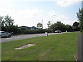
Images are licensed for reuse under creativecommons.org/licenses/by-sa/2.0
Notes
- Clicking on the map will re-center to the selected point.
- The higher the marker number, the further away the image location is from the centre of the postcode.
Image Listing (240 Images Found)
Images are licensed for reuse under creativecommons.org/licenses/by-sa/2.0
Image
Details
Distance
1
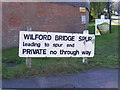
Widford Bridge Spur sign
Off the A1152 Widford Bridge Road
Image: © Geographer
Taken: 19 Sep 2011
0.03 miles
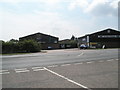
2
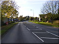
A1152 Wilford Bridge Road
Near the Industrial Estate and Church View Close
Image: © Geographer
Taken: 24 Oct 2008
0.03 miles
3
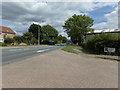
A1152 Wilford Bridge Road, Melton
At the junction with Spur End
Image: © Geographer
Taken: 17 Aug 2018
0.03 miles
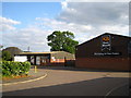
5
Looking across the A1152 towards the vets
Image: © Basher Eyre
Taken: 9 Aug 2010
0.04 miles
6
Looking from Church View Close onto the A1152
Image: © Basher Eyre
Taken: 9 Aug 2010
0.04 miles
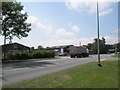
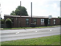
7
Trading estate off Wilford Bridge Road
Image: © Chris Holifield
Taken: 20 May 2011
0.04 miles
8
Church View Close, Melton
At the junction with the A1152 Wilford Bridge Road & Spur End
Image: © Geographer
Taken: 17 Aug 2018
0.04 miles
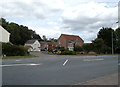
10

Junction of the A1152 and Church View Close
Image: © Basher Eyre
Taken: 9 Aug 2010
0.04 miles