IMAGES TAKEN NEAR TO
Western Avenue, FELIXSTOWE, IP11 9TS
Introduction
This page details the photographs taken nearby to Western Avenue, IP11 9TS by members of the Geograph project.
The Geograph project started in 2005 with the aim of publishing, organising and preserving representative images for every square kilometre of Great Britain, Ireland and the Isle of Man.

There are currently over 7.5m images from over14,400 individuals and you can help contribute to the project by visiting https://www.geograph.org.uk
Image Map
Images are licensed for reuse under creativecommons.org/licenses/by-sa/2.0
Notes
- Clicking on the map will re-center to the selected point.
- The higher the marker number, the further away the image location is from the centre of the postcode.
Image Listing (12 Images Found)
Images are licensed for reuse under creativecommons.org/licenses/by-sa/2.0
Image
Details
Distance
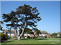
2
Houses on Roman Way
A footpath cuts through the housing estate from the church towards the sea front.
Image: © Andrew Hill
Taken: 14 Aug 2009
0.12 miles
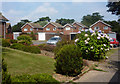
3
Houses across Cliff Road
Modern houses with good sea views.
Image: © Andrew Hill
Taken: 14 Aug 2009
0.20 miles
4
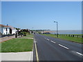
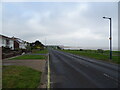
Road to Felixstowe Ferry
Good view towards Bawdsey and the mouth of the Deben
Image: © Nigel Freeman
Taken: 17 Aug 2005
0.22 miles
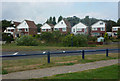
9
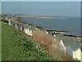
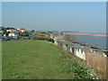
Mouth of the Deben River
You can see the Knolls clearly
Image: © Nigel Freeman
Taken: 17 Aug 2005
0.24 miles