IMAGES TAKEN NEAR TO
Ferry Road, FELIXSTOWE, IP11 9RT
Introduction
This page details the photographs taken nearby to Ferry Road, IP11 9RT by members of the Geograph project.
The Geograph project started in 2005 with the aim of publishing, organising and preserving representative images for every square kilometre of Great Britain, Ireland and the Isle of Man.

There are currently over 7.5m images from over14,400 individuals and you can help contribute to the project by visiting https://www.geograph.org.uk
Image Map
Images are licensed for reuse under creativecommons.org/licenses/by-sa/2.0
Notes
- Clicking on the map will re-center to the selected point.
- The higher the marker number, the further away the image location is from the centre of the postcode.
Image Listing (15 Images Found)
Images are licensed for reuse under creativecommons.org/licenses/by-sa/2.0
Image
Details
Distance
3
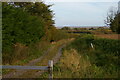
Track leading east off Ferry Road, Felixstowe
Image: © Christopher Hilton
Taken: 19 Oct 2022
0.16 miles
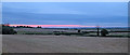
5
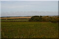
View north from Ferry Road, Felixstowe
Behind the trees to the right at the masts of yachts moored in the River Deben at Felixstowe Ferry.
Image: © Christopher Hilton
Taken: 19 Oct 2022
0.16 miles
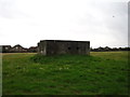
6
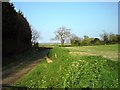
Private Track
Leading through farmland by Fleet House towards the golf links and then the sea.
Image: © Tim Marchant
Taken: 19 Apr 2009
0.18 miles
7
Lane junction
Looking onto the corner of Ferry Road from the start of Marsh Lane.
Image: © Andrew Hill
Taken: 14 Aug 2009
0.19 miles
8
Marsh Lane
A quiet lane leading north towards Kingsfleet.
Image: © Tim Marchant
Taken: 19 Apr 2009
0.20 miles
9
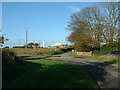
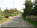
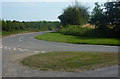
Road Junction
Road junction looking towards Lauret farm Old Felixstowe Suffolk.
Image: © Keith Evans
Taken: 21 Nov 2006
0.21 miles
10
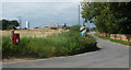
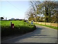
The start of Marsh Lane
At the corner of Ferry Road. The farm on the left is Laurel Farm.
Image: © Andrew Hill
Taken: 14 Aug 2009
0.22 miles