IMAGES TAKEN NEAR TO
Gulpher Road, FELIXSTOWE, IP11 9RE
Introduction
This page details the photographs taken nearby to Gulpher Road, IP11 9RE by members of the Geograph project.
The Geograph project started in 2005 with the aim of publishing, organising and preserving representative images for every square kilometre of Great Britain, Ireland and the Isle of Man.

There are currently over 7.5m images from over14,400 individuals and you can help contribute to the project by visiting https://www.geograph.org.uk
Image Map
Images are licensed for reuse under creativecommons.org/licenses/by-sa/2.0
Notes
- Clicking on the map will re-center to the selected point.
- The higher the marker number, the further away the image location is from the centre of the postcode.
Image Listing (6 Images Found)
Images are licensed for reuse under creativecommons.org/licenses/by-sa/2.0
Image
Details
Distance
1
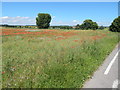
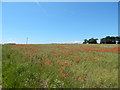
Poppies in Rape fields, Gulpher Road
A bit to the right of Image, looking towards Brick Kiln Cottages.
Image: © Hamish Griffin
Taken: 10 Jun 2014
0.12 miles
2
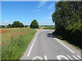
Gulpher Road approaching bend
Brick Kiln Cottages and Hill House Farm are down the track on the left.
Image: © Hamish Griffin
Taken: 10 Jun 2014
0.13 miles
3
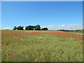
Poppies in Rape fields, Gulpher Road
The trees are at Hill House Farm.
Image: © Hamish Griffin
Taken: 10 Jun 2014
0.13 miles
5
Poppies in Rape fields, Gulpher Road
A bit to the left of Image
Image: © Hamish Griffin
Taken: 10 Jun 2014
0.16 miles
6
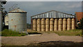
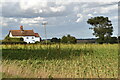
Barn and outbuildings at Gulpher Farm
Big round bales are neatly stacked in the open ended barn.
Image: © Andrew Hill
Taken: 14 Aug 2009
0.24 miles