IMAGES TAKEN NEAR TO
Glenfield Avenue, FELIXSTOWE, IP11 9JG
Introduction
This page details the photographs taken nearby to Glenfield Avenue, IP11 9JG by members of the Geograph project.
The Geograph project started in 2005 with the aim of publishing, organising and preserving representative images for every square kilometre of Great Britain, Ireland and the Isle of Man.

There are currently over 7.5m images from over14,400 individuals and you can help contribute to the project by visiting https://www.geograph.org.uk
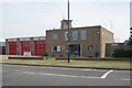
Image Map
Images are licensed for reuse under creativecommons.org/licenses/by-sa/2.0
Notes
- Clicking on the map will re-center to the selected point.
- The higher the marker number, the further away the image location is from the centre of the postcode.
Image Listing (63 Images Found)
Images are licensed for reuse under creativecommons.org/licenses/by-sa/2.0
Image
Details
Distance
1
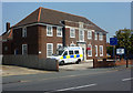
Felixstowe Police Station
Situated on High Road West.
Image: © Andrew Hill
Taken: 14 Aug 2009
0.05 miles
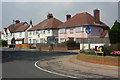
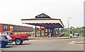
4
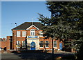
Felixstowe Conservative Club
Imposing 1930s building on High Road West.
Image: © Tim Marchant
Taken: 26 Dec 2008
0.08 miles
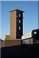
5
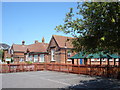
Felixstowe fire station
Felixstowe fire station, High Road West, Felixstowe, Suffolk
Image: © Kevin Hale
Taken: 5 Jun 2010
0.09 miles
6
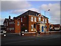
Houses on High Road West
Seen from the roundabout shown on the map.
Image: © Andrew Hill
Taken: 14 Aug 2009
0.10 miles
8
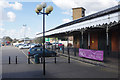
Felixstowe Station
Whereas at one time through services from London and, no doubt, any number of lengthy holiday and excursion trains would have arrived at Felixstowe, the service is nowadays limited to short local trains from Ipswich. So there is no longer a need for long platforms. Even so, whoever thought this arrangement was a good idea really deserves everlasting opprobrium. Trains now terminate at the far end of the old platforms, separated from the terminal buildings (now a shopping centre, of sorts) by a car park. Passengers of course have to make their way across without shelter.
Image: © Stephen McKay
Taken: 26 Mar 2018
0.11 miles
9
Felixstowe station, 1988
View westward, towards Ipswich: ex-GER terminus of the line from Ipswich, also until 12/7/51 from the branch to Felixstowe Pier on the line now used by freight from Felixstowe Port. This station was named 'Felixstowe Town' until 20/2/69.
Image: © Ben Brooksbank
Taken: 29 Apr 1988
0.11 miles
10
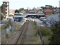
Felixstowe (Town) railway station
Opened as "Felixstowe Town" in 1898 by the Great Eastern Railway at the end of its line from Ipswich, this was much better located for the town centre than the 1877 Image The "Town" suffix was dropped in 1969, a few years after Felixstowe Beach station had closed.
View east towards the buffers. There used to be 4 longer platforms here - the island to the right having been demolished and the track (and further sidings) from the far left having also been removed. The original concourse (in the background, and Grade II listed) has been detached from the operational station and turned into a shopping centre.
Image: © Nigel Thompson
Taken: 9 Apr 2022
0.11 miles