IMAGES TAKEN NEAR TO
Exmoor Road, FELIXSTOWE, IP11 9AZ
Introduction
This page details the photographs taken nearby to Exmoor Road, IP11 9AZ by members of the Geograph project.
The Geograph project started in 2005 with the aim of publishing, organising and preserving representative images for every square kilometre of Great Britain, Ireland and the Isle of Man.

There are currently over 7.5m images from over14,400 individuals and you can help contribute to the project by visiting https://www.geograph.org.uk
Image Map
Images are licensed for reuse under creativecommons.org/licenses/by-sa/2.0
Notes
- Clicking on the map will re-center to the selected point.
- The higher the marker number, the further away the image location is from the centre of the postcode.
Image Listing (26 Images Found)
Images are licensed for reuse under creativecommons.org/licenses/by-sa/2.0
Image
Details
Distance
1
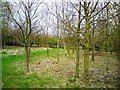
Hazel Coppice
Young trees, mainly hazel, at Abbey Grove.
Image: © Tim Marchant
Taken: 14 Apr 2009
0.14 miles
2
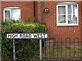
High Road West sign
On High Road West at the junction with Recreation Lane
Image: © Geographer
Taken: 12 Jul 2015
0.16 miles
3
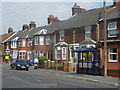
Houses on Walton High Street
Traditional terraced housing between the turns for Exeter Road and Recreation Lane.
Image: © Andrew Hill
Taken: 14 Aug 2009
0.17 miles
4
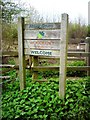
Woodland Trust Sign At Abbey Grove
Entrance to the new woodland.
http://www.wt-woods.org.uk/abbeygrove
Image: © Tim Marchant
Taken: 14 Apr 2009
0.18 miles
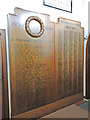
7
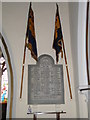
Walton World War One Memorial
The memorial which is high on the chancel wall bears the 70 names of the men lost in WW1. In the tower are tubular bells which also form part of the War Memorial.
The WW2 Memorial details can be seen here > http://www.geograph.org.uk/photo/4622615 http://www.geograph.org.uk/photo/4622609
Image: © Adrian S Pye
Taken: 19 Aug 2015
0.20 miles
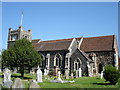
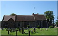
8
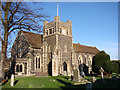
Walton St Mary?s church
In the churchyard near the porch are the remains of a buttress of the earlier church. Also constructed mainly out of septaria, is the wall of the chancel, and it is still serving its purpose. A small Norman priest’s door has been blocked up many years. Entry to the church is through the south door of the tower. There is a sketch of the church as it was about 1623. A black and white photograph shows the church without a tower. There is a rare King James Bible securely kept under glass. The font is a traditional East Anglian octagonal bowl but the shaft has two lions, a wodewose and a green man. A small crude brass of a kneeling choirboy is to William Simond and states simply, ‘Born 1601 - Died 1612’. A larger brass is to William and Agnes Tabard. In the tower are eight tubular bells hung in 1919 as a War Memorial.
Image: © Adrian S Pye
Taken: 8 Feb 2008
0.21 miles
9
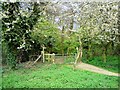
Footpath at the entrance to The Grove
"The Grove is almost 10 acres (4 ha) deciduous woodland situated on the outskirts of Felixstowe. It is one of very few publicly accessible woodlands on the whole peninsula and offers opportunities for relaxing walking."
http://www.suffolkcoastal.gov.uk/yourfreetime/countryside/heath/default.htm
Image: © Tim Marchant
Taken: 14 Apr 2009
0.21 miles
10
Walton War Memorial
This six feet high memorial bears the names of 44 men of walton who died in WW2. On the right is the Roll of Honour of approximately 700 men who served and returned.
The Vestry was built as a Memorial to WW2 and is known as 'The Memorial Vestry' and can be seen here > http://www.geograph.org.uk/photo/4622615
Image: © Adrian S Pye
Taken: 19 Aug 2015
0.21 miles