IMAGES TAKEN NEAR TO
Garrison Lane, FELIXSTOWE, IP11 7RG
Introduction
This page details the photographs taken nearby to Garrison Lane, IP11 7RG by members of the Geograph project.
The Geograph project started in 2005 with the aim of publishing, organising and preserving representative images for every square kilometre of Great Britain, Ireland and the Isle of Man.

There are currently over 7.5m images from over14,400 individuals and you can help contribute to the project by visiting https://www.geograph.org.uk
Image Map
Images are licensed for reuse under creativecommons.org/licenses/by-sa/2.0
Notes
- Clicking on the map will re-center to the selected point.
- The higher the marker number, the further away the image location is from the centre of the postcode.
Image Listing (17 Images Found)
Images are licensed for reuse under creativecommons.org/licenses/by-sa/2.0
Image
Details
Distance
1
Deben High school site, Garrison Lane, Felixstowe
Demolished in 2021.
Image: © Nigel Thompson
Taken: 9 Apr 2022
0.09 miles
2
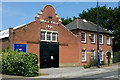
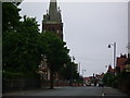
Felixstowe Drill Hall
The 1901 dated Drill Hall on Garrison Lane is the home of the Felixstowe Sea Cadets.
http://www.drillhalls.org/Counties/Suffolk/TownFelixstowe.htm
Image: © Tim Marchant
Taken: 23 Jul 2014
0.20 miles
3
Felixstowe Drill Hall
The 1901 dated Drill Hall on Garrison Lane is the home of the Felixstowe Sea Cadets.
http://www.drillhalls.org/Counties/Suffolk/TownFelixstowe.htm
Image: © Tim Marchant
Taken: 23 Jul 2014
0.20 miles
4
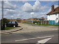
Mill Road Felixstowe
Looking towards the bridge over the railway line with the Felixstowe branch of the Royal British Legion Mill Road Felixstowe Suffolk.
Image: © Keith Evans
Taken: 6 Jan 2009
0.20 miles
5
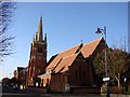
Felixstowe St John the Baptist?s church
This is a traditional church by comparison to St Andrew’s and was designed by Sir Arthur Blomfield in 1894. It is stark in appearance, being constructed of red brick, but it is well proportioned and has a pleasing façade. The south-west tower is square and pinnacled with a contrasting elegant white stone spire and weathers on the buttressing. The interior is also in red brick and is well complemented by fine woodwork.
Image: © Adrian S Pye
Taken: 5 Nov 2007
0.20 miles
6
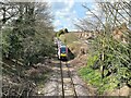
Felixstowe to Ipswich train near the former Felixstowe Beach junction
The branch line, which had curved left towards the docks, closed in 1970. The docks line is still accessible from the Ipswich direction.
Image: © Nigel Thompson
Taken: 9 Apr 2022
0.21 miles
9
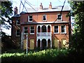
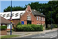
St John's Vicarage
A very sad looking, but very fine house, the vicarage of St John's Church.
Image: © Tim Marchant
Taken: 26 May 2009
0.21 miles
10
Battlefield Cross at Felixstowe
The Cross is in a case at St Peter and St Paul's church in Felixstowe.
It is the original burial cross of Captain W.H.M. Kersey before a permanent headstone was erected.
William Henry Myddleton Kersey was killed 17 October 1917.
He served with 166 Siege Battery of the Royal Garrison Artillery.
He was 25 years old.
He is buried at The Huts Cemetery along with 1,094 others, he was the son of William Edward and Ada Laura Kersey, of Felixstowe.
Image: © Adrian S Pye
Taken: 24 Sep 2020
0.21 miles