IMAGES TAKEN NEAR TO
Tomline Road, FELIXSTOWE, IP11 7NX
Introduction
This page details the photographs taken nearby to Tomline Road, IP11 7NX by members of the Geograph project.
The Geograph project started in 2005 with the aim of publishing, organising and preserving representative images for every square kilometre of Great Britain, Ireland and the Isle of Man.

There are currently over 7.5m images from over14,400 individuals and you can help contribute to the project by visiting https://www.geograph.org.uk
Image Map
Images are licensed for reuse under creativecommons.org/licenses/by-sa/2.0
Notes
- Clicking on the map will re-center to the selected point.
- The higher the marker number, the further away the image location is from the centre of the postcode.
Image Listing (118 Images Found)
Images are licensed for reuse under creativecommons.org/licenses/by-sa/2.0
Image
Details
Distance
1
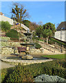
Felixstowe: Cliff Gardens and Town Hall Fountain
The Cliff Gardens are Grade II listed.
Image: © John Sutton
Taken: 26 Dec 2017
0.08 miles
2

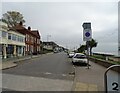
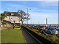
Felixstowe from the pier
View of the town taken from the small pier
Image: © Carl Grove
Taken: 2 Sep 2013
0.08 miles
3
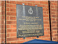
Memorial on Felixstowe Town Hall
The crew of the Lancaster LM258 HA-Q were killed when it crashed into the sea in view of the Town Hall on 25th August 1944.
F/Lt. Douglas Charles HAGGIS (Pilot)
F/O. Glyn Davies Mathias (Flight Engineer)
Sgt. William Augustus Dyer (Navigator)
F/O. Charles Bryce Oxenham (Air Bomber)
F/Sgt. Ernest George Murray (Wireless Operator/Air Gunner)
Sgt. George Covell (Air Gunner)
Sgt. Angus Craig (Air Gunner)
Image: © Adrian S Pye
Taken: 3 Feb 2019
0.08 miles
4
Felixstowe: Town Hall Fountain and War Memorial
Next to the Town Hall on the sea front. Felixstowe was busy on a sunny Boxing Day.
Image: © John Sutton
Taken: 26 Dec 2017
0.08 miles
5
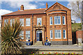
Felixstowe Town Hall
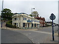
Felixstowe Town Hall, on the seafront, was built in 1892 for the Felixstowe and Walton Joint Board. It subsequently became home to Felixstowe Urban District Council. When that body was disbanded in 1974, the hall was used as the base for Felixstowe Town Council who acquired ownership of the building from Suffolk Coastal District Council in 2007. Since then it has undergone a major refurbishment and, as well as hosting council meetings, it now has a number of other functions including a licence to hold marriages and civil partnerships.
Until the end of the 1990s the building housed the magistrates court. Perhaps the most significant event here was the trial in 1914 of two suffragettes, Evaline Burkitt and Florence Tunks, who were convicted of arson after they burnt down the town's Bath Hotel in furtherance of their cause.
Image: © Stephen McKay
Taken: 26 Mar 2018
0.08 miles
6
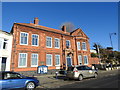
Felixstowe Town Hall
Just above the blue notice board is a memorial for the crew of a Lancaster bomber which crashed into the sea just off Felixstowe beach. https://www.geograph.org.uk/photo/6046044
Image: © Adrian S Pye
Taken: 3 Feb 2019
0.08 miles
7
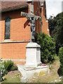
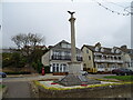
War Memorial outside St John's church, Felixstowe
The memorial is in addition to the one at Undercliff, on the sea front.
More by design than fact there are 29 names for each of the two World Wars. The figures seem to be just representative. The true figures for the town are nearer 163 + for The Great War & 111 + for The Second World War.
Image: © Adrian S Pye
Taken: 21 Aug 2016
0.09 miles