IMAGES TAKEN NEAR TO
Golf Road, FELIXSTOWE, IP11 7NG
Introduction
This page details the photographs taken nearby to Golf Road, IP11 7NG by members of the Geograph project.
The Geograph project started in 2005 with the aim of publishing, organising and preserving representative images for every square kilometre of Great Britain, Ireland and the Isle of Man.

There are currently over 7.5m images from over14,400 individuals and you can help contribute to the project by visiting https://www.geograph.org.uk
Image Map
Images are licensed for reuse under creativecommons.org/licenses/by-sa/2.0
Notes
- Clicking on the map will re-center to the selected point.
- The higher the marker number, the further away the image location is from the centre of the postcode.
Image Listing (21 Images Found)
Images are licensed for reuse under creativecommons.org/licenses/by-sa/2.0
Image
Details
Distance
1
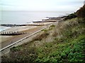
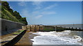
Beach At Old Felixstowe
Sea defences at the foot of the cliff at Old Felixstowe.
Image: © Tim Marchant
Taken: 17 Nov 2008
0.08 miles
2
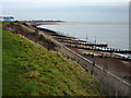
Beach At Old Felixstowe
Looking north-east towards Felixstowe Ferry, Woodbridge Haven and Bawdsey.
Image: © Tim Marchant
Taken: 17 Nov 2008
0.08 miles
4

Groynes on the beach at Old Felixstowe
Image: © Simon Mortimer
Taken: 22 Aug 2020
0.12 miles
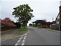
9
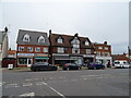
Parade of shops
On High Street East, away from the main centre of Felixstowe.
Image: © Andrew Hill
Taken: 14 Aug 2009
0.18 miles
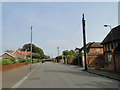
10
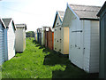
Beach huts in meadow, Old Felixstowe
These beach huts are rather high up on top of the steep cliff and stand in a meadow, rather than on the beach.
Image: © Evelyn Simak
Taken: 25 May 2012
0.19 miles