IMAGES TAKEN NEAR TO
Maybush Lane, FELIXSTOWE, IP11 7LZ
Introduction
This page details the photographs taken nearby to Maybush Lane, IP11 7LZ by members of the Geograph project.
The Geograph project started in 2005 with the aim of publishing, organising and preserving representative images for every square kilometre of Great Britain, Ireland and the Isle of Man.

There are currently over 7.5m images from over14,400 individuals and you can help contribute to the project by visiting https://www.geograph.org.uk
Image Map
Images are licensed for reuse under creativecommons.org/licenses/by-sa/2.0
Notes
- Clicking on the map will re-center to the selected point.
- The higher the marker number, the further away the image location is from the centre of the postcode.
Image Listing (28 Images Found)
Images are licensed for reuse under creativecommons.org/licenses/by-sa/2.0
Image
Details
Distance
1
Custom car display, Felixstowe seafront
The annual gathering of the British custom car fans on Felixstowe front, with a little beach and a rock sea defence groyne visible.
In the distance, in a different square, can be seen the pier and beyond that the cranes at the docks.
Image: © John Goldsmith
Taken: 25 Aug 2007
0.05 miles
2
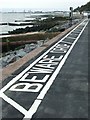
Beware drop
Painted warning along the sea front Felixstowe Suffolk.
Image: © Keith Evans
Taken: 11 Sep 2008
0.06 miles
3
Cobbolds Point
A bright, early morning and high tide.
Image: © Tim Marchant
Taken: 3 Nov 2010
0.06 miles
4
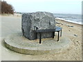
Rock And Seat
This rock and seat has replaced http://www.geograph.org.uk/photo/959158 http://www.geograph.org.uk/photo/959167 sometime since 2008 at Felixstowe, Suffolk.
Image: © Keith Evans
Taken: 6 Mar 2014
0.06 miles
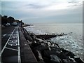
5
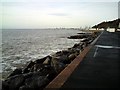
Felixstowe Shore
View from opposite Brook Lane and the Fludyers along the shore towards the town.
Image: © Tim Marchant
Taken: 3 Nov 2010
0.07 miles
6
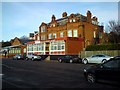
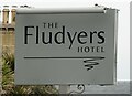
The Fludyer Arms
"The Fludyer name comes from Sir Samuel Fludyer - grandson of the better known Sir Samuel Fludyer (1705-1768) the Lord Mayor of London in 1760. ... The current brick building was built in 1903 and both brick and timber buildings obviously co-existed alongside each other for a time. A stable block, which is now part of the hotel as a garage / storage area was built behind the wooden structure.
During 1940/1941 we understand a light gun (machine gun ?) was installed in the restaurant overlooking the beach - if anyone has any pictures? - we would be delighted to learn more." Source: http://www.jgrange.com/fludyers/history.html
Image: © Tim Marchant
Taken: 3 Nov 2010
0.07 miles
7
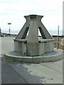
Seat made out of a reef unit
This reef unit was presented by Jackson Civil Engineering to celebrate the completion of Cobbolds Point Coast Protection Scheme for Suffolk Coastal district Council October 2000 it now forms a public bench Felixstowe Suffolk. See http://www.geograph.org.uk/photo/959167 for another view with more of them put to their normal use. This seat was replaced sometime in the following years see http://www.geograph.org.uk/photo/3879920 for photo of new seat.
Image: © Keith Evans
Taken: 11 Sep 2008
0.07 miles
8
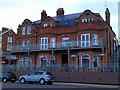
The Fludyer Arms
Historic seafront hotel after its recent refurbishment see Image
http://www.fludyerarmshotel.co.uk/
Image: © Tim Marchant
Taken: 11 Jun 2013
0.07 miles
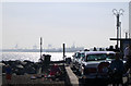
9
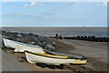
Boats on the beach at Cobbolds Point
Looking east from Undercliff Road East.
Image: © Simon Mortimer
Taken: 22 Aug 2020
0.08 miles