IMAGES TAKEN NEAR TO
Rosebery Road, FELIXSTOWE, IP11 7JR
Introduction
This page details the photographs taken nearby to Rosebery Road, IP11 7JR by members of the Geograph project.
The Geograph project started in 2005 with the aim of publishing, organising and preserving representative images for every square kilometre of Great Britain, Ireland and the Isle of Man.

There are currently over 7.5m images from over14,400 individuals and you can help contribute to the project by visiting https://www.geograph.org.uk
Image Map
Images are licensed for reuse under creativecommons.org/licenses/by-sa/2.0
Notes
- Clicking on the map will re-center to the selected point.
- The higher the marker number, the further away the image location is from the centre of the postcode.
Image Listing (25 Images Found)
Images are licensed for reuse under creativecommons.org/licenses/by-sa/2.0
Image
Details
Distance
1
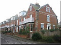
Berners Road
In the 1890s this road was called Ocean Terrace. Felixstowe was a fashionable resort for the middle classes and some of these houses were holiday second homes.
Image: © Mark Murphy
Taken: 5 Jan 2008
0.08 miles
3
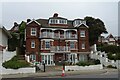
Harvest House
Now converted to residential apartments, this former hotel was the headquarters of Fisons Fertilisers until 20 years ago.
Image: © michael wade
Taken: 26 May 2005
0.16 miles
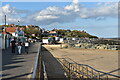
5
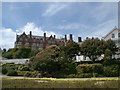
Felixstowe - Promenade by Undercliff Rd E
Image: © Colin Park
Taken: 25 Sep 2016
0.17 miles
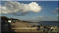
6
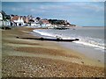
The beach at Undercliff Road East, Felixstowe
Looking east from the promenade at the foot of Bath Hill.
Image: © Simon Mortimer
Taken: 22 Aug 2020
0.17 miles
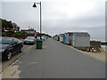
9
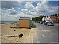
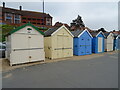
Beach huts
On Undercliff Road East in Felixstowe.
Image: © DS Pugh
Taken: 30 Jul 2012
0.18 miles
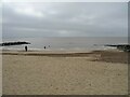
10
Felixstowe Beach
By Undercliff Road East just after high tide.
Image: © Tim Marchant
Taken: 29 Mar 2009
0.19 miles