IMAGES TAKEN NEAR TO
Quilter Road, FELIXSTOWE, IP11 7JL
Introduction
This page details the photographs taken nearby to Quilter Road, IP11 7JL by members of the Geograph project.
The Geograph project started in 2005 with the aim of publishing, organising and preserving representative images for every square kilometre of Great Britain, Ireland and the Isle of Man.

There are currently over 7.5m images from over14,400 individuals and you can help contribute to the project by visiting https://www.geograph.org.uk
Image Map
Images are licensed for reuse under creativecommons.org/licenses/by-sa/2.0
Notes
- Clicking on the map will re-center to the selected point.
- The higher the marker number, the further away the image location is from the centre of the postcode.
Image Listing (10 Images Found)
Images are licensed for reuse under creativecommons.org/licenses/by-sa/2.0
Image
Details
Distance
1
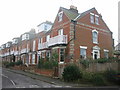
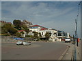
Berners Road
In the 1890s this road was called Ocean Terrace. Felixstowe was a fashionable resort for the middle classes and some of these houses were holiday second homes.
Image: © Mark Murphy
Taken: 5 Jan 2008
0.17 miles
2
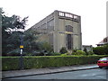
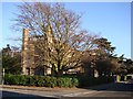
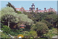
St Andrews Church, Felixstowe
Photo of the east front. Note the rust staining to the concrete - this is widespread, in patches, around the building now.
Image: © Tim Marchant
Taken: 30 Sep 2008
0.18 miles
3
Felixstowe St Andrew?s church
This modern church has been described as many things. To me it has little appeal. Plans for a church here were mooted in 1898. The land was given by Captain Pretyman and in 1907 a temporary timber and corrugated iron structure was built. It was, however, more attractive than today’s concrete edifice. The design for the present church can be attributed to Hilda Mason who worked with H. Munro Cautley. Some of the traditional aspects of church building can be seen in the design, such as the clerestory and the basic Perpendicular style. It was completed in 1931 but lacks the tower that it was originally designed to have. My opinion is that it would have improved the appearance and made it look more like a church and less like a multi-storey car park. Just as well it is hidden by trees.
Image: © Adrian S Pye
Taken: 5 Nov 2007
0.19 miles
4
St Andrew Felixstowe
The church of St Andrew, Felixstowe Suffolk. For more info see http://www.suffolkchurches.co.uk/felixstan.htm
Image: © Keith Evans
Taken: 13 Jan 2009
0.20 miles
5
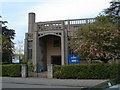
St. Andrew's Church
Building of reinforced concrete built in the 1930s
Image: © michael wade
Taken: 26 May 2005
0.21 miles
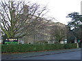
7
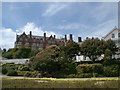
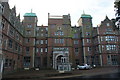
Harvest House
Now converted to residential apartments, this former hotel was the headquarters of Fisons Fertilisers until 20 years ago.
Image: © michael wade
Taken: 26 May 2005
0.24 miles
9
Harvest House, Felixstowe
Formerly the Felixstowe Hotel, the house is being converted into residential apartments.
Image: © nick macneill
Taken: 17 May 2006
0.25 miles
10
Spa Pavilion
Seaside theatre, built in the early 20th century, used for a wide range of entertainments
Image: © michael wade
Taken: 26 May 2005
0.25 miles