IMAGES TAKEN NEAR TO
Parker Avenue, FELIXSTOWE, IP11 4BB
Introduction
This page details the photographs taken nearby to Parker Avenue, IP11 4BB by members of the Geograph project.
The Geograph project started in 2005 with the aim of publishing, organising and preserving representative images for every square kilometre of Great Britain, Ireland and the Isle of Man.

There are currently over 7.5m images from over14,400 individuals and you can help contribute to the project by visiting https://www.geograph.org.uk
Image Map
Images are licensed for reuse under creativecommons.org/licenses/by-sa/2.0
Notes
- Clicking on the map will re-center to the selected point.
- The higher the marker number, the further away the image location is from the centre of the postcode.
Image Listing (32 Images Found)
Images are licensed for reuse under creativecommons.org/licenses/by-sa/2.0
Image
Details
Distance
1
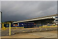
Depots and car parks along Parker Avenue, Felixstowe
Image: © Christopher Hilton
Taken: 26 Sep 2021
0.08 miles
2
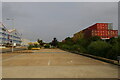
Depots and car parks along Parker Avenue, Felixstowe
Image: © Christopher Hilton
Taken: 26 Sep 2021
0.09 miles
3
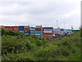
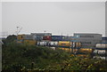
Felixstowe Container Terminal
The railway cutting is now much shallower and the trees have given way to bushes so it is once again possible to see the container terminal with the railway running alongside the security fence.
Image: © Glen Denny
Taken: 12 Jun 2010
0.10 miles
8
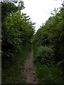
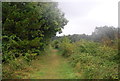
Footpath towards Trimley
The path is paralleled on both sides by trees and bushes obscuring the views of both the railway and the agricultural land.
Image: © Glen Denny
Taken: 12 Jun 2010
0.18 miles
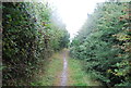
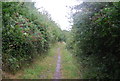
9
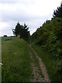
Footpath towards Trimley
The footpath continues towards Trimley with the trees at the top of the railway embankment obscuring the view of the track below. At this point a line of trees begin separating the path from the agricultural land.
Image: © Glen Denny
Taken: 12 Jun 2010
0.18 miles