IMAGES TAKEN NEAR TO
Oysterbed Road, FELIXSTOWE, IP11 4AZ
Introduction
This page details the photographs taken nearby to Oysterbed Road, IP11 4AZ by members of the Geograph project.
The Geograph project started in 2005 with the aim of publishing, organising and preserving representative images for every square kilometre of Great Britain, Ireland and the Isle of Man.

There are currently over 7.5m images from over14,400 individuals and you can help contribute to the project by visiting https://www.geograph.org.uk
Image Map
Images are licensed for reuse under creativecommons.org/licenses/by-sa/2.0
Notes
- Clicking on the map will re-center to the selected point.
- The higher the marker number, the further away the image location is from the centre of the postcode.
Image Listing (44 Images Found)
Images are licensed for reuse under creativecommons.org/licenses/by-sa/2.0
Image
Details
Distance
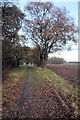
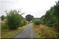
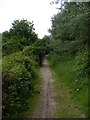
1
Bridleway towards Fagbury Cliff
To the left of the bridleway is still agricultural land but to the right is the embankment surrounding the western end of the container terminal.
Image: © Glen Denny
Taken: 12 Jun 2010
0.05 miles
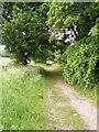
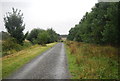
3
Bridleway to Trimley Marshes
This track is part of the waymarked Stour and Orwell Walk. It seems a world away from the busy Felixstowe port, which in fact is less than 50 metres away. A high bank to the left of this photo separates the farmland from the port.
Image: © Bob Jones
Taken: 5 Dec 2008
0.06 miles
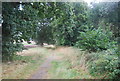
4
Bridleway towards Trimley Marshes Nature Reserve
This track is part of the Stour and Orwell Walk and leads to the nature reserve's visitor centre. Behind the trees on the left is the embankment surrounding the western end of the container terminal.
Image: © Glen Denny
Taken: 12 Jun 2010
0.06 miles
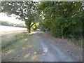

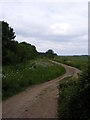
10
Approaching Fagbury Cliff
The bridleway begins to climb to take it to the level of Fagbury cliff and the embankment surrounding this end of the container terminal. When it reaches the trees in the top centre of the image the bridleway then makes a sharp left turn.
Image: © Glen Denny
Taken: 12 Jun 2010
0.07 miles