IMAGES TAKEN NEAR TO
Tollemache Walk, FELIXSTOWE, IP11 2GH
Introduction
This page details the photographs taken nearby to Tollemache Walk, IP11 2GH by members of the Geograph project.
The Geograph project started in 2005 with the aim of publishing, organising and preserving representative images for every square kilometre of Great Britain, Ireland and the Isle of Man.

There are currently over 7.5m images from over14,400 individuals and you can help contribute to the project by visiting https://www.geograph.org.uk
Image Map
Images are licensed for reuse under creativecommons.org/licenses/by-sa/2.0
Notes
- Clicking on the map will re-center to the selected point.
- The higher the marker number, the further away the image location is from the centre of the postcode.
Image Listing (77 Images Found)
Images are licensed for reuse under creativecommons.org/licenses/by-sa/2.0
Image
Details
Distance
1
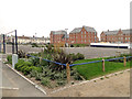
Car Park and new buildings
The new development will surround the Martello Tower.
Image: © Adrian S Pye
Taken: 17 Sep 2014
0.03 miles
2
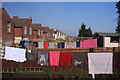
Over the fence
The rear gardens of houses in Langer Road, Felixstowe.
Image: © Bob Jones
Taken: 26 Sep 2008
0.04 miles
4
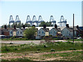
Houses dwarfed by cranes in Felixstowe docks
Image: © Evelyn Simak
Taken: 25 May 2012
0.06 miles
5
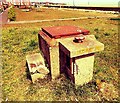
ROC Post Felixstowe
Felixstowe had a very short-lived ROC post located in a compound to the East of Langer Road. It became operational in 1962 but was closed in September 1968. Presently there is heavy development in this part of Felixstowe with many new homes being built; at present it is uncertain if this post will survive as the land it is sited on may be redeveloped. Currently the post stands in good condition and has been sealed with a special metal hatch to prevent entry.
Image: © Cud05
Taken: 7 May 2015
0.06 miles
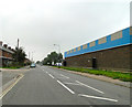
6
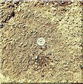
Rivet Felixstowe 153 Langer Road
Rivet, Felixstowe, 153 Langer Road (A154 South) pavement adjacent to Indo European Foods Factory Entrance.
Image: © Cud05
Taken: 11 Feb 2016
0.07 miles
7
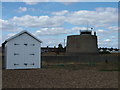
Martello Tower, South Felixstowe
Now used as a coastguard lookout, this Martello tower is one of three surviving at Felixstowe, the others being at the Old Felixstowe end. I'm sure there would have been more towards the centre of the front but I guess they were demolished because the land was valuable for something else, or maybe the sea has taken them. The Aldeburgh one (the most northerly) has lost part of its moat and one at Bawdsey is threatened by the sea. Despite their bulk they can be demolished, as witnessed by the foundations in the gardens of Bawdsey Manor.
In the foreground we see a very smart beach hut.
Image: © John Goldsmith
Taken: 29 Aug 2009
0.07 miles
8
Commemorative stone on the Esplanade, Felixstowe - plaque
For a wider view of this location see > http://www.geograph.org.uk/photo/2961669.
Image: © Evelyn Simak
Taken: 25 May 2012
0.07 miles
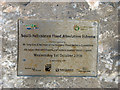
9
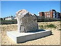
Commemorative stone on the Esplanade, Felixstowe
It commemorates the completion of the Felixstowe Flood Alleviation Scheme, and is dated 1 October 2008 > http://www.geograph.org.uk/photo/2961671.
Image: © Evelyn Simak
Taken: 25 May 2012
0.07 miles
10

Martello tower, custom car
This Martello tower, on the southern part of Felixstowe sea front, is now used as a coastguard lookout station. The car is one of the hundreds allowed onto the front at the annual gathering by custom car fans.
Image: © John Goldsmith
Taken: 29 Aug 2009
0.07 miles