IMAGES TAKEN NEAR TO
Capel Drive, FELIXSTOWE, IP11 2FR
Introduction
This page details the photographs taken nearby to Capel Drive, IP11 2FR by members of the Geograph project.
The Geograph project started in 2005 with the aim of publishing, organising and preserving representative images for every square kilometre of Great Britain, Ireland and the Isle of Man.

There are currently over 7.5m images from over14,400 individuals and you can help contribute to the project by visiting https://www.geograph.org.uk
Image Map
Images are licensed for reuse under creativecommons.org/licenses/by-sa/2.0
Notes
- Clicking on the map will re-center to the selected point.
- The higher the marker number, the further away the image location is from the centre of the postcode.
Image Listing (9 Images Found)
Images are licensed for reuse under creativecommons.org/licenses/by-sa/2.0
Image
Details
Distance
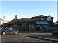
4
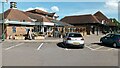
Felixstowe-The Owl and the Pussycat
Next to Morrison's.
Image: © Ian Rob
Taken: 19 May 2022
0.10 miles
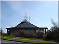
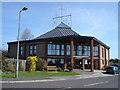
7
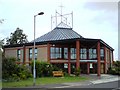
Christ Church Felixstowe
"Christ Church is an ecumenical Anglican church in Felixstowe, Suffolk. The church was founded in 1989 (then known as Cavendish Community Church)"
http://christchurchfelixstowe.org.uk/
Image: © Tim Marchant
Taken: 27 May 2009
0.13 miles
8
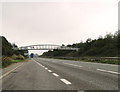
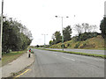
Footbridge over the A14 near the Trimleys
Image: © Adrian S Pye
Taken: 17 Sep 2014
0.24 miles